This Summer's Temperatures Higher Than Average... High Pressure Near Korea
Heavy Rain Due to El Ni?o Returning After 3 Years... Localized Downpours Expected to Increase
As scorching weather continues from May, the Korea Meteorological Administration (KMA) forecasted a high possibility of a heatwave comparable to a typical midsummer starting in June. Due to the earlier onset of El Ni?o, which is returning to the Korean Peninsula after three years, there is even a possibility of surpassing the record-breaking heatwave of 1994.
According to the KMA's summer climate outlook on the 23rd, the average temperature this summer (June to July) is expected to be higher than usual. This year, the sea surface temperature in the western Pacific region is about 0.5 to 1 degree Celsius higher than normal, and if this trend continues, the high-pressure circulation near Korea will strengthen, causing temperatures to rise.
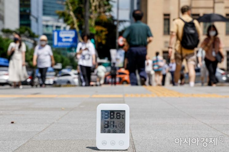 On the 25th, when a heatwave advisory was issued for most regions nationwide, the ground temperature was displayed on a thermometer at the Gwanghwamun Intersection in Jongno-gu, Seoul. Photo by Jinhyung Kang aymsdream@
In June, under the influence of a mobile high-pressure system, daytime temperatures will rise, leading to high-temperature phenomena, and there will likely be a large temperature difference between day and night. Accordingly, the average temperature in June this year is predicted to be higher than or similar to the normal range (20.2 to 21.8 degrees Celsius) with a probability of over 40% for each.
In July and August, the Pacific high-pressure system is expected to cause sweltering heat. The hottest summer in Korea was July 1994, with the highest number of heatwave days (17.7 days) and tropical nights (8.5 days), which was also caused by a strongly developed high-pressure system.
This year, the return of a super El Ni?o is also anticipated. El Ni?o is a phenomenon where the average sea surface temperature remains at least 0.5 degrees Celsius above normal for more than five months. The U.S. National Oceanic and Atmospheric Administration (NOAA) and the KMA believe that the La Ni?a phenomenon (the opposite of El Ni?o), which lasted for three years from 2020, has ended, and El Ni?o is very likely to develop fully this summer.
When El Ni?o arrives, Korea tends to experience increased rainfall and lower temperatures mainly in the southern regions between mid-July and mid-August. However, due to the La Ni?a that persisted for the past three years, the current sea surface temperature remains higher than normal, increasing the likelihood of global temperature rise and thus a higher chance of elevated temperatures in Korea as well.
The atmospheric circulation caused by El Ni?o is also likely to bring heavy rainfall to Korea. However, the KMA drew a line against unofficial online rumors claiming "it will rain every day except for three days in July." Woo Jin-gyu, a spokesperson for the KMA, stated, “The further ahead the weather forecast goes, the greater the uncertainty,” and dismissed such information as “data with no value for forecasting.” He added, “Even looking at the KMA’s ten-day forecast, there are continuous changes, and no country in the world can accurately predict the weather one or two months ahead.”
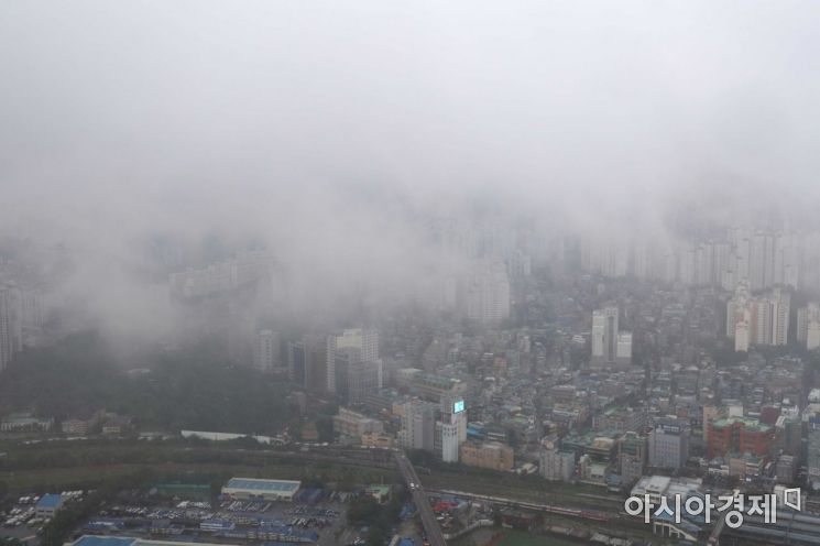 On the 9th, when record-breaking heavy rain fell mainly in Seoul and the central region, the sky viewed from the Yeouido 63 Square Observatory was cloudy. Photo by Mun Ho-nam munonam@
However, the possibility of sudden heavy rainfalls occurring more frequently in narrow areas, like the flooding in Gangnam, Seoul, last August, continues to be raised. This is due to cold air from the Arctic pushing down into East Asia and colliding more strongly with the North Pacific air mass, making the linear precipitation band (a narrow, long band of monsoon rain) more distinct. As sudden heavy rainfall becomes more frequent, precise forecasting has become even more difficult.
With growing concerns about heatwaves and heavy rain this summer, the government has also introduced several measures. The heatwave warning system, which was originally issued based solely on temperature, will now be judged according to the actual perceived level of heat. The official criteria for issuing heatwave warnings will change from the daily maximum temperature (warnings issued if the daily maximum temperature is expected to be 33 degrees Celsius or higher for two or more days, and alerts if 35 degrees Celsius or higher for two or more days) to the daily maximum apparent temperature. The apparent temperature is calculated by reflecting humidity and wind in addition to temperature.
Additionally, the government distributed heatwave response funds to local governments on the 8th, about a month earlier than last year, encouraging prompt spending. Furthermore, construction sites are recommended to halt work when the heatwave crisis alert reaches the ‘severe’ level. Energy vouchers averaging about 43,000 won for summer energy costs will be provided to eligible households, and cooling costs of 115,000 won per month will be given to senior centers.
© The Asia Business Daily(www.asiae.co.kr). All rights reserved.


