Analysis of Jijayeon Results Reveals Large-Scale Surface Deformation Observed
In February, it was revealed that the large-scale surface deformation occurred as a result of the T?rkiye earthquake.
The Korea Institute of Geoscience and Mineral Resources (KIGAM) announced on the 13th that it published a report analyzing traces of surface ruptures left by two strong earthquakes (magnitude 7.8 and 7.5) that occurred in T?rkiye, about 7,000 km away from the Korean Peninsula, on February 6, using satellite data.
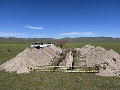 Mongolia Mogod Fault Exploration Site. Photo by Korea Institute of Geoscience and Mineral Resources (KIGAM)
The T?rkiye earthquake was observed at all broadband observation stations operated by the Geological Disaster Research Division of KIGAM. In particular, the P-wave, which first reached Korea, was detected at Baengnyeongdo about 9 minutes and 50 seconds after the earthquake occurred. The characteristics of the seismic motion (displacement) tended to increase toward the east and north, suggesting that the lower crust of the Korean Peninsula is not uniform.
Previously, KIGAM confirmed that the T?rkiye earthquake also affected groundwater levels in the Korean Peninsula. Among the 11 nationwide groundwater observation networks operated by the Groundwater Environment Research Center, changes in groundwater levels were detected at the Mungyeong and Gangneung observation wells. The changes were first observed at the Mungyeong observation well (about 11 minutes and 9 seconds after the earthquake). During the magnitude 7.8 mainshock, groundwater levels rose by about 7 cm in Mungyeong and about 3 cm in Gangneung. During the magnitude 7.5 aftershock, only the Mungyeong observation well showed a groundwater level change (3 cm decrease). The institute analyzed that earthquakes of magnitude 7.5 or higher can affect groundwater even in Korea, which is more than 7,000 km away.
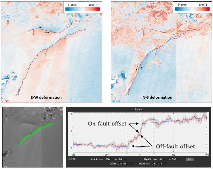
The Geological Disaster Research Division of KIGAM used satellite data to precisely observe the large-scale surface deformation phenomenon accompanying the T?rkiye earthquake. Surface displacement was observed using Interferometric SAR (InSAR) and Offset Tracking techniques. Data from the Sentinel-1 satellite operated by the European Space Agency (ESA) was used. This C-band SAR satellite can capture an area of about 250 km. Additionally, to remove phase differences caused by terrain, the Shuttle Radar Topography Mission (SRTM) digital elevation model data with 30 m spatial resolution provided by NASA was used. This data contains 3D coordinate information of elevation for each location.
As a result, horizontal displacements of up to 3.8 m were measured in the southern part (Section A) of the East Anatolian Fault surface rupture, up to 5.7 m in the northern part (Section B), and up to 6.3 m in the ?ardak Fault (Section C). Horizontal surface displacements perpendicular to the fault at a distance of 40 km were measured as maximum deformations of 3.5 m, 4.6 m, and 6.5 m, respectively. Correlation analysis of optical satellite images before and after the earthquake showed left-lateral displacements where the northwest block of the East Anatolian Fault moved southwest and the southeast block moved northeast. Left-lateral motion was also observed in the northern block of the ?ardak Fault moving westward. In particular, displacement profile analysis crossing the fault at one point of the East Anatolian Fault revealed about 6.6 m of horizontal displacement, of which approximately half, 3.5 m, occurred not along the fault line but in the fault surroundings extending several hundred meters.
KIGAM stated, "The surface displacement information measured in this analysis mostly agrees with the results of analyses by advanced international earthquake research groups," and added, "We plan to verify the results and improve accuracy through comparative analysis with other radar images, GNSS data, and field data." They are also preparing analyses using Korea’s own satellite (Kompsat-5).
The report also includes the ‘Research Status of Major Overseas Earthquakes’ focusing on the area around the Korean Peninsula. Through joint research status and achievements at the Mongol Mogod Fault, which is most similar to Korea’s seismic environment, multidisciplinary and new research technologies are being developed to overcome the limitations of domestic fault research. The research team newly revealed in 2022, through optical image correlation analysis of the 1995 magnitude 6.9 Kobe earthquake in Japan, that displacements of about 1.5 m, which can be measured immediately after the earthquake in field surveys, were dispersed around the fault zone. The report also introduces the analysis results of the potential impact of the 2011 Great East Japan Earthquake on the seismic environment of the Korean Peninsula.
© The Asia Business Daily(www.asiae.co.kr). All rights reserved.
![Clutching a Stolen Dior Bag, Saying "I Hate Being Poor but Real"... The Grotesque Con of a "Human Knockoff" [Slate]](https://cwcontent.asiae.co.kr/asiaresize/183/2026021902243444107_1771435474.jpg)


