Observations from the Korea Institute of Geoscience and Mineral Resources
The earthquake in T?rkiye that occurred on the 6th (local time) was found to have changed the groundwater levels in South Korea. Although the epicenters in South Korea and T?rkiye are as far as 7,400 km apart, the earthquake was so powerful with a magnitude of over 7.5 that it affected not only the ground but also the groundwater levels, according to analysis.
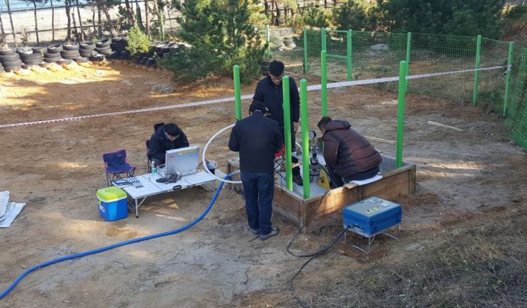 Researchers at the Groundwater Environment Research Center of the Korea Institute of Geoscience and Mineral Resources (KIGAM) are conducting earthquake-groundwater linked monitoring. Photo by KIGAM
The Korea Institute of Geoscience and Mineral Resources (KIGAM) announced on the 14th that Dr. Lee Su-hyung's research team detected changes in groundwater levels at two domestic groundwater observation wells (Mungyeong, Gangneung) following the main shock (magnitude 7.8) and aftershock (magnitude 7.5) of the T?rkiye earthquake on the 6th. In particular, at the Mungyeong observation well, the groundwater level rose by about 7 cm after the main shock and then dropped by 3 cm following the aftershock. At the Gangneung observation well, a 3 cm rise in groundwater level was detected after the main shock.
When an earthquake occurs, seismic waves exert pressure on the rocks surrounding the aquifer containing groundwater, causing compression and expansion in the aquifer, which leads to repeated fluctuations (oscillation) in groundwater levels. An aquifer is a geological formation that contains groundwater. It is composed of materials with many pores such as sand, gravel, silt, and clay. Among these, sand, gravel, and alluvial mixtures have larger pore sizes, allowing groundwater to flow easily, whereas silt and clay have smaller pore sizes, making groundwater movement difficult. At the Mungyeong observation well, the impact on groundwater levels from the main shock and aftershock of the T?rkiye earthquake was clearly detected.
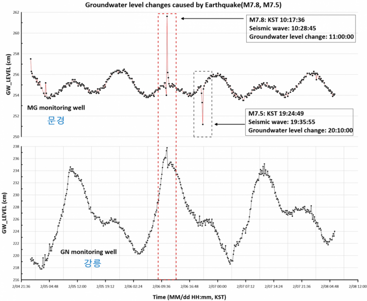 Since the Turkey earthquake (magnitude 7.8), the groundwater observation well water level in Mungyeong has risen by 7cm, and the groundwater observation well water level in Gangneung has risen by 3cm. During the magnitude 7.5 earthquake, the groundwater level in Mungyeong dropped by 3cm. Image provided by KIGAM
Dr. Lee Su-hyung's research team, the only group in South Korea conducting research on earthquake-groundwater changes, analyzed through this study that earthquakes with magnitudes above 7.5 can affect groundwater in South Korea even when occurring more than 7,000 km away. The team has previously observed and studied groundwater level changes during the Indonesian earthquake (2010, magnitude 7.7), the Great East Japan Earthquake (2011, magnitude 9.0), the Nepal earthquake (2015, magnitude 7.8), and the New Zealand earthquake (2021, magnitude 7.8) which occurred 9,300 km away, publishing their findings in international academic journals.
Dr. Lee explained, "When a strong earthquake occurs, irregular outflow and inflow can happen due to rapid groundwater movement," adding, "Since this can seriously affect underground environments such as aquifers rich in groundwater, radioactive waste sites, and contaminated areas, continuous research through linked earthquake-groundwater monitoring is necessary."
© The Asia Business Daily(www.asiae.co.kr). All rights reserved.


