Passing the west coast instead of the north of Kyushu, Osaka landfall at 9 AM on the 19th
Closest approach from early morning to daytime on the 19th, 30-60mm per hour along the Gyeongsang coastal area
Jeju Island mountain area expected rainfall adjusted from 150mm to 20-80mm
Maximum wave height 10m, beware of swell waves in the East Sea and South Sea
 Typhoon Nanmadol is expected to pass along the western coast of Kyushu as it moves more eastward than anticipated. (Data provided by the Korea Meteorological Administration)
[Asia Economy Reporter Han Jinju] As Typhoon Nanmadol moves along a path shifted more to the east than expected, the coastal areas of the Gyeongsang region will be the most affected. The time when the typhoon comes closest is from the early morning to daytime on the 19th, with heavy rainfall exceeding 150mm expected along the Gyeongsang coastal areas by the 19th.
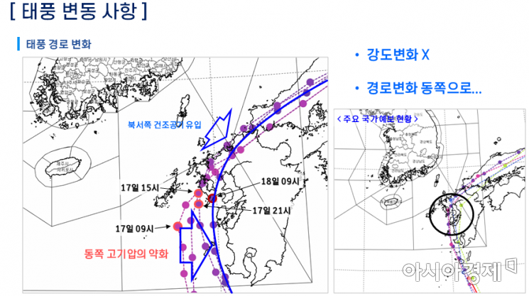
The Korea Meteorological Administration (KMA) held an ad-hoc briefing on the 18th regarding Typhoon Nanmadol and weather forecasts, announcing that the typhoon's center position has shifted eastward and will move slightly more southeast than previously forecasted. Initially, it was expected to make landfall north of Kyushu, but now it is predicted to pass along the western coast of Kyushu.
Woo Jin-gyu, a forecast analyst at KMA, explained, "The predicted path has changed to one where the typhoon moves along the western coast of Kyushu, and the timing of the typhoon turning northeast remains unchanged. The impact on South Korea is not significant, and there is no change in the typhoon's intensity, but the Gyeongsang coastal area will be the most affected, and the expected rainfall in the mountainous areas of Jeju has also been adjusted."
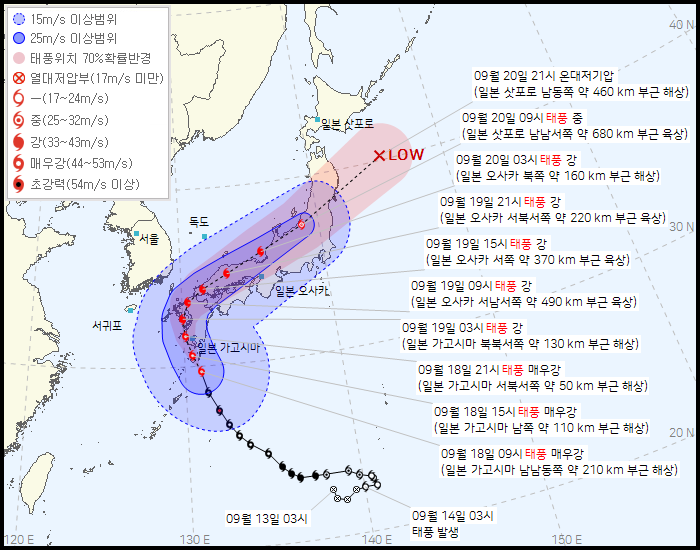
Currently, Typhoon Nanmadol has developed to an 'ultra-powerful' intensity but has slightly weakened to a 'very strong' intensity, maintaining a central pressure of 935 hPa while moving at 24 km/h in the sea 210 km south-southeast of Kagoshima. It is expected to reach 50 km northwest-west of Kagoshima by 3 a.m. on the 19th and make landfall near 490 km west-southwest of Osaka, Japan, by 9 a.m. The central pressure at 3 a.m. on the 19th is expected to be 950 hPa, similar to Typhoon Hinnamnor, with a strong wind radius of 390 km and maximum instantaneous wind speed of 43 m/s.
The edge of the North Pacific high-pressure system has shifted eastward, causing the typhoon's path to shift more eastward than previously predicted. The dry air north of South Korea, which influences the typhoon's northeastward turn, has also adjusted the path. Consequently, the expected rainfall amounts have been slightly revised. The previous forecast predicted over 150mm of rain in Jeju's mountainous areas, but the revised forecast expects 20 to 80mm.
Analyst Woo said, "Since the typhoon will pass close to the western coast of Kyushu, Jeju Island will fall within the strong wind category, and a strong wind advisory may be issued instead of a typhoon advisory. Even the western coast, where no typhoon advisory is issued, may experience strong winds, so caution is needed for strong winds until the 19th."
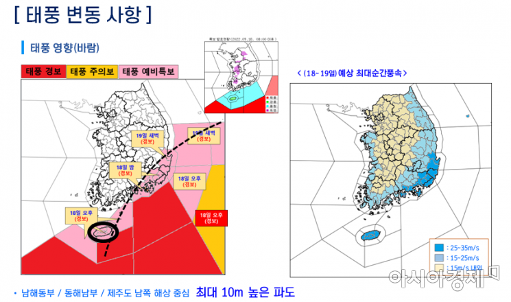 From the afternoon of the 18th, typhoon warnings are expected to be issued mainly for the South Sea and East Sea areas, and from the early morning of the 19th, typhoon warning-level alerts are anticipated for the eastern regions. (Data provided by the Korea Meteorological Administration)
The time when Typhoon Nanmadol comes closest to South Korea is from the early morning to daytime on the 19th. During this period, heavy rainfalls of 30 to 60 mm per hour are expected mainly along the Gyeongsang coastal areas, so preparations for flood damage are necessary. Rain will begin in Jeju and the Yeongdong region of Gangwon Province from the afternoon of the 18th, expanding to the Gyeongsang coastal areas from night. Rain will start to cease in Jeju from early morning on the 19th, stopping in northern Gangwon Yeongdong and inland Gyeongsang areas by afternoon, and ending in central and southern Gangwon Yeongdong and the eastern coast of Gyeongsang in the late afternoon.
From the 18th to the 19th, rainfall amounts will be over 150mm in the Gyeongsang coastal areas, 50 to 100mm in other Gyeongsang coastal areas, Gangwon Yeongdong, Ulleungdo, and Dokdo, 20 to 80mm in eastern inland Gyeongsang and Jeju mountainous areas, and 5 to 40mm in eastern Jeolla, western inland Gyeongsang, and Jeju Island. In Gangwon Yeongdong, unstable atmospheric conditions caused by the collision of dry air descending from the north and warm, humid air flowing in from the south will result in heavy rain.
Despite the adjustment in the typhoon's path, the impacts of strong winds and high waves remain unchanged. Waves as high as 10 meters are expected mainly in the eastern South Sea, southern East Sea, and southern seas around Jeju. Until the 20th, caution is advised for swell waves along the East Coast. Strong winds reaching 35 m/s are expected along the Gyeongsang coastal areas and Jeju.
© The Asia Business Daily(www.asiae.co.kr). All rights reserved.
![Clutching a Stolen Dior Bag, Saying "I Hate Being Poor but Real"... The Grotesque Con of a "Human Knockoff" [Slate]](https://cwcontent.asiae.co.kr/asiaresize/183/2026021902243444107_1771435474.jpg)


