Discovering Municipal Utilization Models Using Digital Spatial Information of Terrain and Buildings and 628 Types of Public Data
[Asia Economy Reporter Lim Cheol-young] A contest is being held to discover spatial information analysis maps that combine various administrative information such as safety, welfare, and environment in the ‘digital version of Seoul’ implemented in a 3D virtual space, which can be utilized for diverse policy decisions.
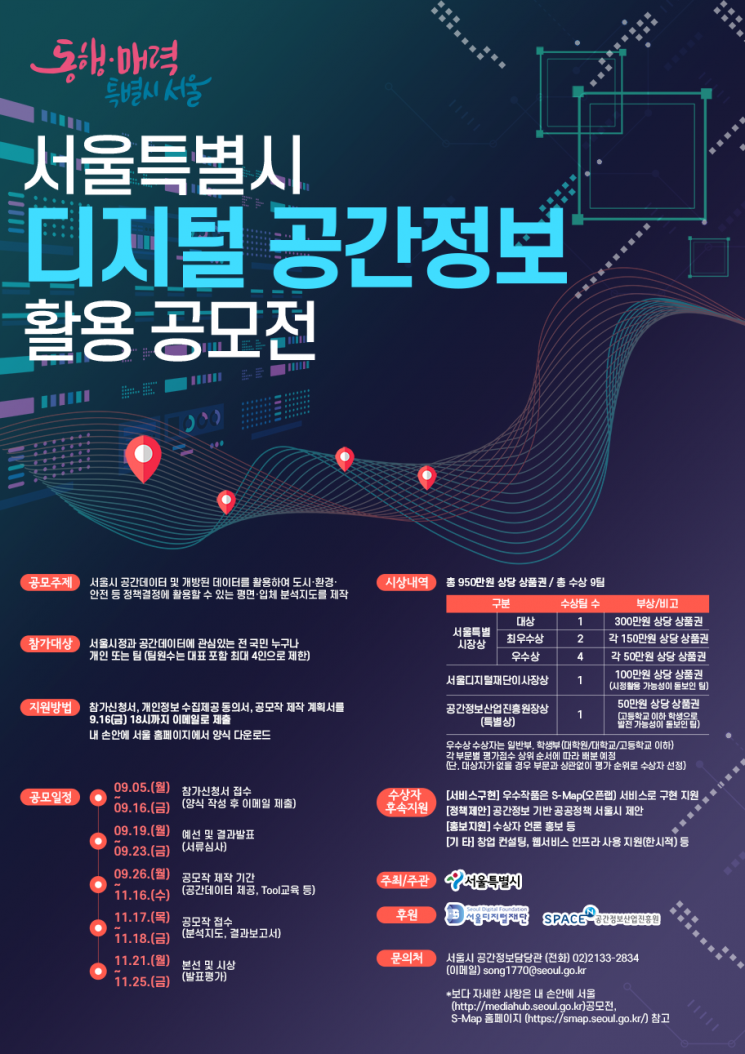
On the 10th, Seoul City announced that it will hold the '2022 Digital Spatial Information Analysis and Utilization Contest' and will accept applications from July 5 to 16. The contest is sponsored by the ‘Spatial Information Industry Promotion Agency,’ which operates the Ministry of Land, Infrastructure and Transport’s 3D map service, and the ‘Seoul Digital Foundation,’ which innovates city administration using new technologies.
Contest participants are required to create 2D or 3D maps that can be used for policy decisions by utilizing digital spatial information owned by Seoul City and public data related to safety, welfare, environment, etc. For example, if a current status map is created using construction site location information and fine dust concentration data by district, it can be used for construction site map inspections to reduce fine dust. Using information related to alley safety such as security lights and CCTV along with 3D building models, safety blind spots can also be identified.
The contest themes can be chosen from designated tasks or free topics. In particular, the city plans to provide spatial information that was previously limitedly disclosed to the public, such as aerial photographs and 3D building and facility models, if necessary for the theme and participants. The goal is to discover utilization models that differentiate from previous contests.
Through a total of two stages of preliminary and final judging, nine winning teams will be selected, and winners will receive prizes and follow-up support benefits. Awards include the Seoul Mayor’s Award for Grand Prize (1), Excellence Award (2), and Merit Award (4), as well as sponsor awards such as the Seoul Digital Foundation Chairman’s Award (1) and the Spatial Information Industry Promotion Agency Director’s Award (1).
Outstanding winning works will be actively considered for adoption as Seoul City policies, and to ensure continuous upgrades of the analysis maps, implementation support will be provided through the ‘S-Map Open Lab (virtual experiment space)’ service. Additionally, startup support benefits such as entrepreneurship consulting provided by the Spatial Information Industry Promotion Agency are also prepared.
Park Jong-su, Seoul City Smart City Policy Officer, said, “We hope this contest will serve as a catalyst for actively introducing various city administration utilization models and new technologies using digital spatial information into Seoul City policies and services, and become an opportunity for citizens to demonstrate their spatial information utilization capabilities.” He added, “We look forward to the interest and participation of citizens who have brilliant ideas and spatial information utilization skills.”
© The Asia Business Daily(www.asiae.co.kr). All rights reserved.
![Clutching a Stolen Dior Bag, Saying "I Hate Being Poor but Real"... The Grotesque Con of a "Human Knockoff" [Slate]](https://cwcontent.asiae.co.kr/asiaresize/183/2026021902243444107_1771435474.jpg)


