Geographically Low-Lying Area... Structure Where Surrounding Rainwater Gathers
Helpless Against Record Heavy Rain Despite Increased Rainwater Treatment Capacity
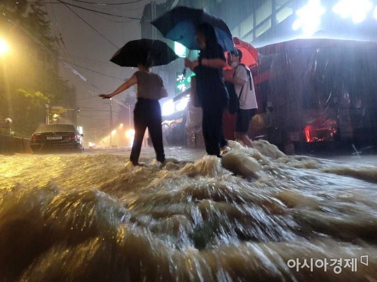 On the night of the 8th, when heavy rain fell mainly in the central region, citizens hurried their steps on the street near Nonhyeon Station in Gangnam-gu, Seoul. Photo by Mun Ho-nam munonam@
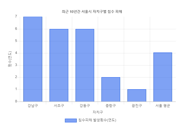
The area most affected by the record-breaking heavy rain in 80 years was once again Gangnam, known for its high elevation. Despite frequent flooding and subsequent improvement measures, the fear of flood damage in Gangnam persists. Analysts suggest that a combination of operational and managerial shortcomings, such as insufficient capacity of the sewer system (large pipes that collect wastewater from multiple drains and send it to treatment plants), and the geographical characteristic of Gangnam being a low-lying area where rainwater accumulates, contributed to the situation.
According to the Seoul Metropolitan Government Disaster and Safety Countermeasures Headquarters as of 10:30 a.m. on the 9th, subway stations including Sadang Station, Samsung Station, Isu Station, Daechi Station, Gwangmyeong Sageori Station, Sindaebang Station, Sangdo Station, Seowon Station, Seolleung Station, Dongjak Station, and Gubanpo Station were flooded. Additionally, underpasses in Gaepo, Irwon, Gubanpo, Geumha, Yeomgok-dong West, Guro Station, Guro, west side of Mokdong Bridge, Singil, Dongjak, and Sinwon were submerged.
In particular, the area around Gangnam Station is known as a habitual flood zone. It suffered severe flood damage in 2010 and 2012. Subsequently, in 2015, the Seoul Metropolitan Government announced the ‘Comprehensive Drainage Improvement Plan for Gangnam Station Area and Flood-Prone Areas’ and pledged to gradually enhance flood response capabilities by 2019. However, in August 2020, the Gangnam Station area was flooded again, turning into a waterlogged zone.
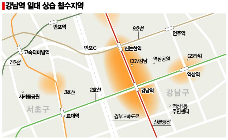
Seoul city attributes the core reason for flooding near Gangnam Station to the ‘jar-shaped terrain.’ This refers to a funnel-shaped lowland area that is lower in the middle and higher on both sides. The designated water level for measuring Han River floods is 15.74 meters, but the Gangnam Station area is at an elevation of 12.2 meters above sea level. It is more than 17 meters lower than nearby Nonhyeon-dong or Yeoksam-dong, and the area around Banpo-dong’s Express Bus Terminal is also over 16 meters lower than adjacent areas. As a result, during heavy rain, water from higher areas rushes toward Gangnam Station, causing flooding.
Other major factors contributing to habitual flooding include △incorrect installation of sewer pipes on Gangnam-daero (reverse slope) △insufficient water flow capacity upstream of Banpo Stream △construction errors in sewer pipes near the Samsung office building (reverse slope). When it rains in the Gangnam area, water must be drained through sewers into Banpo Stream in Seocho-gu. To prepare for heavy rain with an hourly rainfall of 95 mm, which occurs once every 30 years, Seoul completed the ‘Banpo Stream Watershed Separation Tunnel Project’ in June this year. However, even this was helpless against the record-breaking heavy rain. A Seoul city official explained, "The watershed separation tunnel is designed to handle about 85 mm of rain per hour, but yesterday’s rainfall was about 116 mm per hour," adding, "The volume of rain exceeded what even the latest facilities can handle." The Seoul city government believes this flood occurred under the same structural conditions analyzed in 2015.
This heavy rain caused particularly severe damage to high-rise apartments in the Gangnam area. In Seocho-gu Banpo-dong, the underground parking lots of Apartment Complex A and Apartment Complex B in Seocho-dong were filled with water, flooding vehicles. Commercial areas around Gangnam Station and parking lots of villas in Bangbae-dong also suffered flood damage. The flooding of the underground mechanical rooms caused a temporary power outage at an officetel near Yeoksam Elementary School.
Mr. Shin, a resident of Apartment Complex C near Gangnam Station, said, "During the last flood, only the area around Jinheung Apartment was submerged, but this time water reached near Yeoksam Elementary School, and the flooded underground parking lots of apartments expanded the affected area."
Despite repair work by the Seoul city government, repeated flood damage in Gangnam Station has led to calls for a change in flood management strategies. Simply expanding the capacity of drainage facilities is insufficient for safe and sustainable flood response. Due to climate change, rainfall predictions have become difficult, and the frequency of rainfall exceeding capacity has increased.
Kim Seong-eun, Associate Research Fellow at the Safety and Environment Research Division of the Seoul Institute, said, "The frequency of rainfall exceeding the design capacity of Seoul’s stormwater control system is increasing. In areas with high density of factors causing flood damage such as population, traffic volume, and infrastructure, flood management focusing on ‘resilience’?the ability to quickly recover and restore urban functions even after flooding?is becoming more important." A Seoul city official stated, "We will analyze more causes and review additional measures while promoting flood preparedness projects."
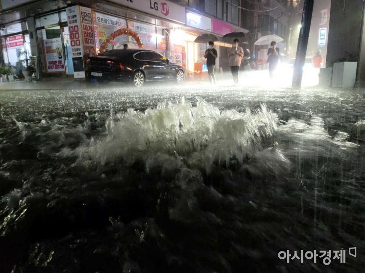 On the night of the 8th, when heavy rain fell mainly in the central region, citizens hurried their steps on the street near Nonhyeon Station in Gangnam-gu, Seoul. Photo by Mun Ho-nam munonam@
◆Vehicle Flooding Accidents Also Frequently Occur in Gangnam Area
An analysis by Hyundai Marine & Fire Insurance’s Traffic Climate Environment Research Institute of vehicle flooding accidents in Seoul from June to August between 2012 and 2020 found that 82.3% of vehicle flooding accidents occurred on days when hourly rainfall exceeded 35 mm.
By district, Seocho-gu accounted for the highest proportion of flood damage at 31.7%, followed by Gangnam-gu (14.3%), Yangcheon-gu (8.2%), Gangseo-gu (6.7%), and Geumcheon-gu (6.5%).
© The Asia Business Daily(www.asiae.co.kr). All rights reserved.


