Typhoon Aere's Impact on Korea Not Significant
High Waves in Jeju and Southern Coast, Swells Occur with Wind
Strong Showers Inland Due to Atmospheric Instability Until the 6th
Nationwide Rainfall Possible After the 7th Due to Stationary Front
[Asia Economy Reporter Han Jinju] Typhoon Aere, the 4th typhoon of the season, is passing through the distant southern sea of Jeju Island and heading towards Japan, and it is expected to have little impact on South Korea. From the 4th to the 6th, most regions nationwide will experience a heatwave, and strong showers will fall in inland areas.
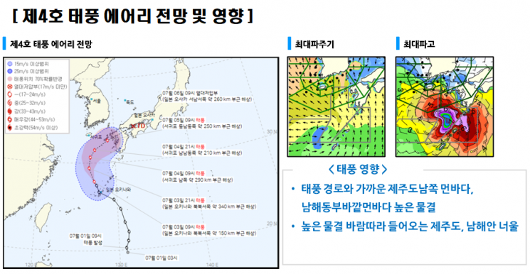
On the 3rd, the Korea Meteorological Administration held a briefing to announce the current status of the typhoon and weather forecast. It forecasted that Typhoon Aere, which has not further developed, will pass south of Jeju and exit towards Japan, having little impact on South Korea. Swell waves with high waves will occur along the winds following the typhoon around Jeju Island and the southern coast.
Typhoon Aere is expected to pass 290 km south of Seogwipo at 9 a.m. on the 4th and pass near 250 km southeast of Seogwipo on July 5. It is forecasted to weaken into a tropical depression by 9 a.m. on the 6th and exit near 260 km southwest of Osaka.
Lee Kwang-yeon, a forecaster and analyst at the Korea Meteorological Administration, explained, "Typhoon Aere will pass through the distant southern sea of Jeju and head towards Japan, causing high waves in the distant southern sea of Jeju and rain in Jeju and some parts of the southern coast. Rainfall of 20 to 60 mm is expected in Jeju and the southern coastal areas, with some places receiving up to 80 mm."
From the 3rd to the 6th, most regions nationwide will continue to experience hot weather. Except for some mountainous areas, most regions will have a maximum perceived temperature of over 30 degrees Celsius, with inland areas reaching over 33 degrees Celsius.
Due to the hot and humid air swept in by Typhoon Aere and strong sunlight, strong showers accompanied by gusts and thunder and lightning are expected in inland areas. The hot and humid air flowing in from the south and the heated ground cause a large temperature difference between the upper and lower layers of the atmosphere, leading to atmospheric instability and resulting in showers.
From the 7th onwards, there is a possibility of rain nationwide. Hot and humid air will move northward, and cold and dry air descending from Mongolia will meet over the Chinese continent, forming a stationary front accompanied by a low-pressure system. As the stationary front moves from west to east, rain is expected around the 7th.
The forecaster explained, "The stationary front will move quickly and be strong, so rain will last for more than a day. The timing of the activation of the stationary front is fluid due to the rearrangement of pressure systems, making it difficult at this point to predict the amount of precipitation, start time, and concentrated areas."
© The Asia Business Daily(www.asiae.co.kr). All rights reserved.
![Clutching a Stolen Dior Bag, Saying "I Hate Being Poor but Real"... The Grotesque Con of a "Human Knockoff" [Slate]](https://cwcontent.asiae.co.kr/asiaresize/183/2026021902243444107_1771435474.jpg)


