[Asia Economy Reporter Moon Hyewon] As Typhoon No. 4 ‘Aere’ moves northward, the Jeju area is expected to come under the typhoon's influence starting from the afternoon of the 4th.
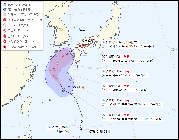
According to the Korea Meteorological Administration on the 3rd, as of 3 a.m. that day, Typhoon Aere was moving north at a speed of 22 km/h in the sea about 100 km north-northwest of Okinawa, Japan.
The typhoon has a central pressure of 994 hPa (hectopascal), a maximum wind speed of 19 m/s, and a strong wind radius of 250 km, indicating relatively weak strength.
The typhoon is predicted to pass through the sea about 350 km south of Seogwipo at 3 a.m. on the 4th, the sea about 170 km east-southeast of Seogwipo at 3 a.m. on the 5th, and then move inland near 350 km west of Osaka, Japan at 3 a.m. on the 6th.
Accordingly, Jeju is expected to be within the typhoon's influence starting from the 4th.
The Korea Meteorological Administration initially forecasted that Typhoon Aere would bypass Jeju and head toward Japan, but since the Jeju area is adjacent to the typhoon's path, preparations for possible damage are necessary.
On the same day, Jeju Province will hold an initial situation assessment meeting for Typhoon No. 4 Aere at 9 a.m., presided over by Governor Oh Young-hoon, and a countermeasure meeting with related agencies at 2 p.m., presided over by Deputy Governor Koo Man-seop.
Governor Oh will also conduct on-site inspections of disaster-vulnerable areas such as Hancheon and Namsugak in Jeju City starting from 10 a.m. on the same day.
© The Asia Business Daily(www.asiae.co.kr). All rights reserved.


