Subtropical High Pressure Stays Long in the South Causing Heatwave; Temperature Drops Sharply from October 15 as Continental High Pressure Expands
Typhoon Chanthu Stagnates Near Shanghai Causing Heavy Rainfall in Jeju Island
[Asia Economy Reporter Han Jinju] This fall's temperature was the fifth highest on record. The temperature fluctuation was the largest ever due to a rapid temperature drop in mid-October.
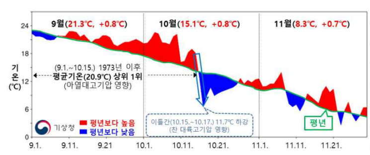
On the 8th, the Korea Meteorological Administration announced the '2021 Fall Climate Analysis Results.' The average temperature this fall was 14.9°C, 0.8°C higher than the normal year, ranking fifth highest historically.
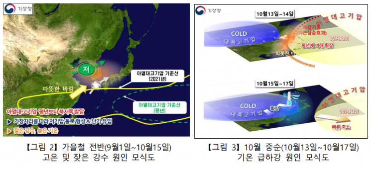
Subtropical high pressure remained over Korea for an extended period during the fall, causing warm weather with high temperatures until mid-October. From early September to mid-October, the average temperature was 20.9°C, the highest since 1973.
After October 15, cold continental high pressure rapidly expanded, causing a sharp temperature drop. From October 15 to 17, the temperature fell by 11.7°C compared to before.
Temperatures in February, March, and the overall fall season were significantly higher than average, making the nationwide average temperature from January to November 14.4°C, the highest on record. The second highest was in 2019, and the third in 2016, with seven of the top ten years occurring since 2010.
Precipitation this fall was 256.4mm, similar to the average. Frequent rain occurred from early September to mid-October due to the influence of a pressure trough, and from mid-October, rain and snow fell mainly in the western regions due to northwesterly winds accompanied by cold air.
In November, continental high pressure expanded twice, and the first snow was observed in the western regions. Seoul experienced its first snow on November 10, 30 days earlier than last year and 10 days earlier than the average.
A total of nine typhoons occurred this fall. Only Typhoon Chanthu (Typhoon No. 14) affected Korea. While moving north, Typhoon Chanthu stalled near the sea off Shanghai, China, causing heavy rainfall over Jeju Island due to the rain cloud band. From September 13 to 17, precipitation reached 1276.5mm at Jindallaebat. The total rainfall in September was 692.4mm in Seogwipo and 348.0mm in Gosan.
Park Kwang-seok, head of the Korea Meteorological Administration, said, "Last fall showed clear climate variability with high temperatures until mid-October followed by a rapid temperature drop. When hazardous weather such as cold waves and heavy snow are expected in winter, we will strengthen intensive monitoring and do our best to ensure that warnings and weather information are delivered promptly."
© The Asia Business Daily(www.asiae.co.kr). All rights reserved.
![Clutching a Stolen Dior Bag, Saying "I Hate Being Poor but Real"... The Grotesque Con of a "Human Knockoff" [Slate]](https://cwcontent.asiae.co.kr/asiaresize/183/2026021902243444107_1771435474.jpg)


