Jeju Northeast Offshore Likely Path Passing South Coast
Up to 300mm in Jeju and 120mm on South Coast of Jeonnam by Morning of 16th
Most Dangerous on 16th-17th...Hourly Rainfall up to 50-80mm in Jeju and South Coast
Jeju Maximum Gusts up to 40m/s, Beware of Strong Winds and Waves
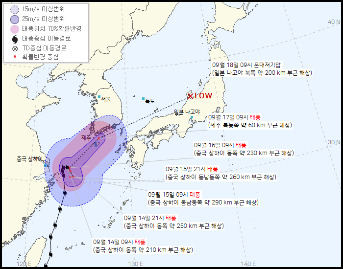 Typhoon Chanthu Expected Path as of 10 AM on September 14 (Source: Korea Meteorological Administration)
[Asia Economy Reporter Han Jinju] Typhoon 'Chantu' is approaching Jeju in the early morning of the 17th and will pass through the southern sea. Jeju will be directly affected by the typhoon from the afternoon of the 16th, Jeolla region from the early morning of the 17th, and Gyeongsang region from the morning of the 17th, so caution is needed for rain and strong wind damage.
On the 14th, the Korea Meteorological Administration held a briefing on the forecast of Typhoon Chantu and predicted that Jeju would receive up to 300mm of rain due to indirect effects of the typhoon until the morning of the 16th, and the southern coast of Jeollanam-do would also see heavy rainfall of about 120mm in some areas. Jeju, located northeast of the typhoon, is expected to receive 100-200mm of rain from that day until the morning of the 16th, Jeollanam-do and the southern coast of Gyeongsangnam-do 20-80mm, and southern Gyeongsang and southern Jeollabuk-do and Gyeongsangbuk-do about 10-40mm. Some areas are expected to have accumulated rainfall reaching 800mm due to continuous rain over several days.
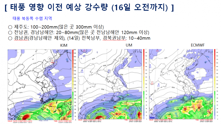 Expected rainfall in Jeju and the southern coast area until the morning of the 16th, indirectly affected by Typhoon Chanthu (Source: Korea Meteorological Administration)
The period of direct impact from the typhoon is from the afternoon of the 16th to the afternoon of the 17th, with hourly rainfall reaching up to 50-80mm. The expected rainfall over two days is up to 150mm in Jeju, with some places exceeding 300mm, and up to 150mm in the southern coast of Jeollanam-do, coastal areas of Gyeongsang, and near Jirisan, with some places exceeding 250mm. During this time, Jeju is expected to experience strong winds with maximum instantaneous wind speeds reaching 40m/s. Coastal areas should also be thoroughly prepared for flooding damage caused by waves.
Han Sang-eun, a meteorological expert at the Korea Meteorological Administration, explained, "The typhoon is expected to stagnate near the east of Shanghai until the morning of the 16th and will be indirectly affected until then. The day most affected by the typhoon will be the 17th, and depending on the movement speed, the impact may continue until the 18th."
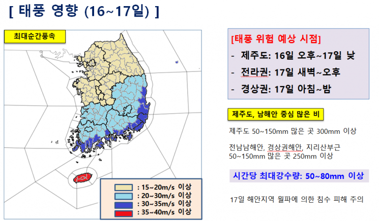 Expected rainfall in Jeju and the southern coast area under the direct influence of Typhoon Chanthu from September 16 to 17 (Source: Korea Meteorological Administration)
As of 9 a.m. on the 14th, Typhoon Chantu's central pressure is 970 hPa, maximum wind speed at the center is 35m/s, and the radius of strong winds is 280km, classifying it as a strong typhoon. Typhoon Chantu stayed in the sea east of Shanghai, China until the 15th, then started moving from the 16th, approaching Jeju in the early morning of the 17th, passing through the southern sea on the same day, and is expected to exit to the southeast sea of Ulleungdo and Dokdo in the early morning of the 18th.
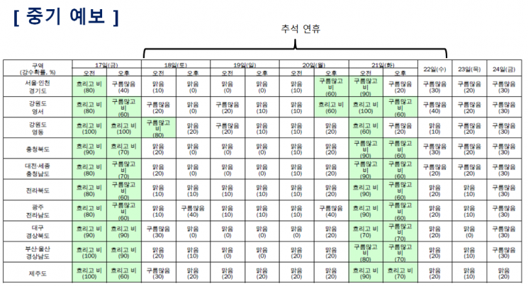
According to the Korea Meteorological Administration's mid-term forecast, the 17th is expected to be cloudy with rain nationwide. The Yeongdong region of Gangwon Province will experience rain until the morning of the 18th due to easterly winds. On the afternoon of the Chuseok holiday on the 20th, rain is expected in the Seoul metropolitan area and Gangwon Yeongseo region, and on the 21st, rain is forecasted in most parts of the country.
At this point, the analysis that the typhoon will pass through the southern sea is dominant, but the possibility of a change in the path cannot be ruled out. This is because the range of the upper and lower atmospheric high pressure systems settled over Korea varies, which could change the typhoon's path to the southern region and inland. Depending on the position and area changes of the high pressure systems at different atmospheric altitudes, the typhoon's movement path and the range of areas affected by the typhoon may vary.
A meteorological expert explained, "If the high pressure strengthens at the surface and lower atmosphere, the typhoon may weaken due to the difference in wind direction with the upper atmosphere. If the typhoon moves slowly and weakens, the stagnation period will be longer, and it may move northward. There remains a possibility that it will pass through the southern region and inland."
© The Asia Business Daily(www.asiae.co.kr). All rights reserved.
![Clutching a Stolen Dior Bag, Saying "I Hate Being Poor but Real"... The Grotesque Con of a "Human Knockoff" [Slate]](https://cwcontent.asiae.co.kr/asiaresize/183/2026021902243444107_1771435474.jpg)


