DGIST Professor Hwang Jaeyoon's Team Develops AI Neural Network Module for Creating World's Highest Performance Digital Maps
[Asia Economy Reporter Kim Bong-su] An artificial intelligence (AI) technology capable of completing the digital mapping of aerial imagery, which used to take over a month, in just seconds has been developed by a domestic research team.
Daegu Gyeongbuk Institute of Science and Technology (DGIST) announced on the 12th that Professor Hwang Jae-yoon's research team in the Department of Information and Communication Convergence has developed a world-class digital map generation AI neural network module that can accurately extract buildings from aerial photographs for remote sensing using deep learning technology.
Recently, with the advancement and performance improvement of deep learning techniques, a field of artificial intelligence, related applied research has been active. Among them, the technology to accurately extract objects such as buildings from aerial imagery is an important technology for digital map production used in military, logistics, autonomous driving, and other fields. However, in the case of low-quality and low-resolution aerial images, existing related technologies have difficulty accurately distinguishing objects, so until now, digital maps have been manually created by people, requiring significant time and cost.
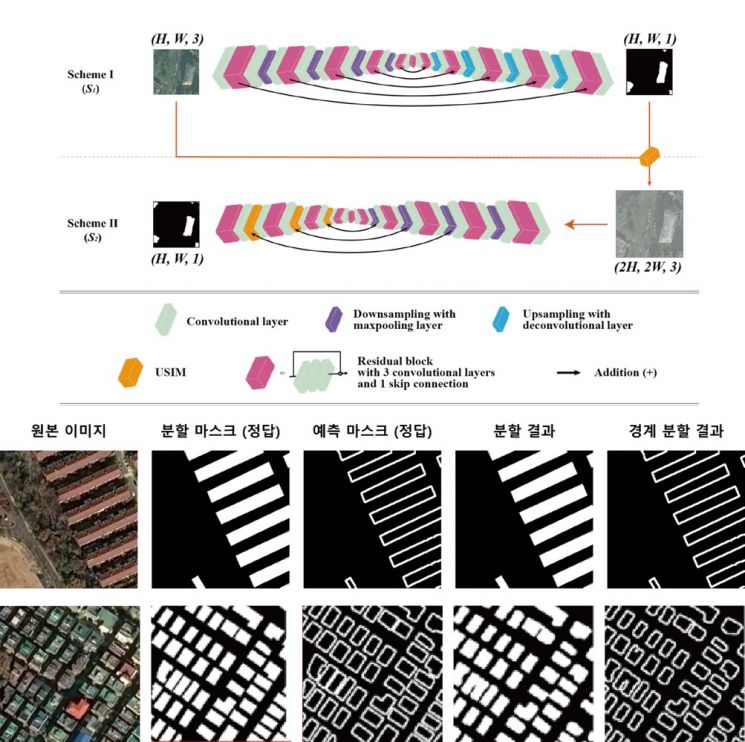
The research team thought that focusing on the boundaries of buildings in aerial images during object detection necessary for automatic digital map production could improve building detection performance, and based on this, they started developing an AI model. The developed AI model enables not only accurate boundary segmentation but also precise detection of building boundaries.
Furthermore, by designing a new learning pipeline and new operators, they developed a new neural network structure that analyzes the correlation between building boundaries and information (entropy) to perform accurate segmentation. The newly developed neural network has the advantage of accurately extracting the shapes and boundaries of buildings from aerial images, significantly improving building extraction performance across various aerial image domains compared to existing methods. It maximizes efficiency to the extent that digital maps, which previously required over a month of manual work, can now be completed in just seconds.
Professor Hwang said, “This is a new neural network that can extract objects from aerial and satellite images with high accuracy,” and added, “If related technologies are further improved in the future, they are expected to be applied in various fields such as medical imaging, positively influencing the development of AI technology.”
The research results were published on the 26th of last month in ‘Transactions on Geoscience and Remote Sensing,’ a top journal in the related field of the Institute of Electrical and Electronics Engineers (IEEE).
© The Asia Business Daily(www.asiae.co.kr). All rights reserved.
![Clutching a Stolen Dior Bag, Saying "I Hate Being Poor but Real"... The Grotesque Con of a "Human Knockoff" [Slate]](https://cwcontent.asiae.co.kr/asiaresize/183/2026021902243444107_1771435474.jpg)


