Possibility of temperatures rising up to 38°C in western regions from the 21st
Localized heavy rain continues after the monsoon "Guerrilla-style rainfall more dangerous"
This year, high pressure systems split east-west, differing from 2018's pressure patterns
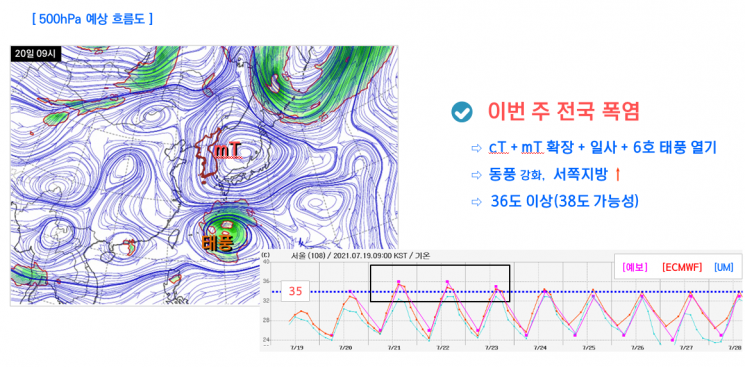
[Asia Economy Reporter Han Jinju] As of the 19th, the monsoon season ends nationwide, and from the 21st to the 25th, a heatwave with temperatures soaring above 38 degrees Celsius will begin.
At a briefing held by the Korea Meteorological Administration on the 20th, forecaster analyst Woo Jin-gyu stated, "The North Pacific High is covering our country, marking the end of the monsoon as of yesterday, and heatwaves will dominate going forward. Between the 21st and 25th, some western regions may see temperatures rise above 38 degrees Celsius."
With the North Pacific High affecting Korea until the 24th and the Tibetan High approaching from the west, daytime maximum temperatures will continue to rise above 35 degrees Celsius. Due to the influence of easterly winds, temperatures in the western regions will increase significantly, necessitating preparations for the heatwave, according to the Meteorological Administration.
However, even after the monsoon ends, localized heavy rain showers will continue. Localized heavy rain following the monsoon is characterized by the sudden development of rain clouds, making it difficult to predict.
Forecaster analyst Woo said, "Even after the monsoon ends, depending on changes in the pressure system, strong showers and concentrated heavy rain may occur in Korea. If moisture related to typhoons flows in, various forms of rainfall can appear. These guerrilla-type showers can pour a large amount of rain in a short time, potentially causing greater damage."
From late July, the overlapping area of the Tibetan High and the North Pacific High will disappear, leading to a different pattern from the extreme heatwave seen in 2018. At that time, the two highs overlapped and remained for a long period, whereas this year, the Tibetan High is expected to be positioned to the west and the North Pacific High to the southeast.
A variable factor is that a low-pressure system moving northward could draw up heat from the south. Forecaster analyst Woo explained, "If a typhoon passes near Korea, it could sweep heat into the country. Typhoon No. 6 is expected to pass south of Korea and head toward Shanghai or southern China, potentially pulling heat into Korea."
The Meteorological Administration requested restraint in using the term "heat dome," emphasizing that this summer's pattern differs from the prolonged heatwave caused by overlapping highs in 2018.
Forecaster analyst Woo added, "Even if a vertical high-pressure pattern forms, whether it results in an extreme heatwave depends on how long it persists. Temperatures could rise and then fall like a typical summer. This year, from late July, the two highs will be separated east and west, so heat will not continuously accumulate as it did in 2018."
Typhoon No. 6 "In-fa," which formed southeast of Okinawa, Japan on the 18th, is blocked by the Tibetan High and North Pacific High, preventing it from moving north toward Korea. Instead, it is likely to move westward, passing through Taiwan and making landfall in southern China. The Meteorological Administration states that the possibility of it changing course toward Korea is low.
© The Asia Business Daily(www.asiae.co.kr). All rights reserved.
![User Who Sold Erroneously Deposited Bitcoins to Repay Debt and Fund Entertainment... What Did the Supreme Court Decide in 2021? [Legal Issue Check]](https://cwcontent.asiae.co.kr/asiaresize/183/2026020910431234020_1770601391.png)


