[Asia Economy Honam Reporting Headquarters Reporter Park Nosik] Namwon City in Jeonbuk announced on the 23rd that it has converted the coordinates, which serve as the surveying standards for cadastral maps and forest maps, into the internationally standardized World Geodetic System coordinates.
The World Geodetic System refers to a geodetic system used globally as a common reference for location, and it is an Earth-centered coordinate system whose origin is the center of the Earth rather than a specific region. It closely matches the shapes of countries worldwide, making it an international standard geodetic system with no regional errors.
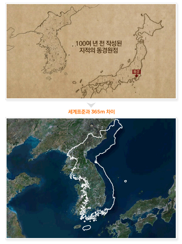
Korea's coordinate system has been used continuously since the 1910s when Japan, during its colonial rule, started land surveys based on the Tokyo Datum, which was set according to Japan's topography.
The Tokyo Datum differs from the World Geodetic System by about 365 meters southeast, making it impossible to use unified values with global coordinates. This causes difficulties in utilizing spatial information built on the World Geodetic System and its convergence and fusion, and it does not fit Korea's topography well, leading to many problems.
Accordingly, Namwon City completed the observation of World Geodetic System coordinates for 5,764 cadastral control points, which serve as the basis for cadastral surveying, starting in 2010. After error verification such as area and location checks, the coordinate conversion for 278,981 land parcels was completed.
Through this coordinate conversion, the city expects to eliminate the remnants of Japanese colonial rule that have lasted for 110 years, contribute to the development of various contents through the convergence of cadastral records and spatial information industries, and facilitate the utilization of new technologies related to the 4th Industrial Revolution as well as linkage with national projects under the Korean New Deal policy.
Lee Hwan-joo, Mayor of Namwon City, said, “By registering cadastral records at their correct locations using the internationally standardized World Geodetic System coordinates, we expect to greatly contribute to protecting citizens' property rights by enhancing the credibility of cadastral records through the provision of accurate and prompt land information services.” He added, “We will strive to eliminate the remnants of Japanese colonial rule and complete Korea-style digital cadastral systems.”
© The Asia Business Daily(www.asiae.co.kr). All rights reserved.
![Clutching a Stolen Dior Bag, Saying "I Hate Being Poor but Real"... The Grotesque Con of a "Human Knockoff" [Slate]](https://cwcontent.asiae.co.kr/asiaresize/183/2026021902243444107_1771435474.jpg)


