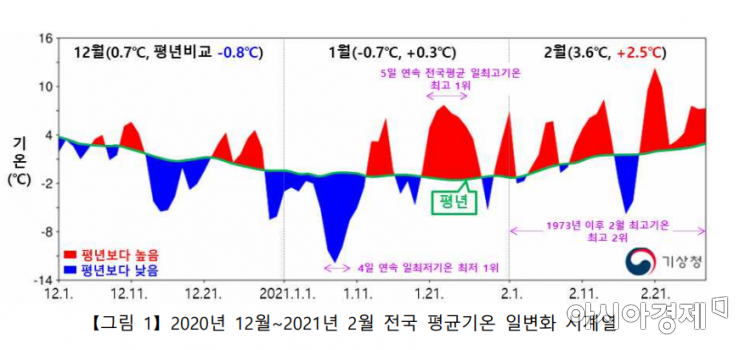
Temperature fluctuation range second largest since 1973
Arctic warming weakens jet stream, bringing cold air down
Warm air influx from south causes struggle
[Asia Economy Reporter Han Jinju] Last winter recorded the largest temperature fluctuations ever, breaking records for both the lowest and highest temperatures. In December and January, cold air descended due to Arctic warming, bringing a cold wave, while in February, warm southern winds led to spring-like warm weather.
According to the '2020 Winter Climate Analysis Results' announced by the Korea Meteorological Administration on the 7th, the temperature fluctuation from December last year to February this year was the second largest since 1973. The fluctuation in average maximum temperature ranked 2nd, and the fluctuation in average minimum temperature ranked 4th.
From January 7 to 10 this year, the daily minimum temperature was the lowest ever recorded for four consecutive days, and from January 21 to 25, the daily maximum temperature was the highest ever recorded for five consecutive days. The average temperature fluctuation in January was 5.3 degrees, the largest ever recorded.
In February, under the influence of a mobile high-pressure system and strong sunlight, the maximum temperature ranked 2nd highest. The fluctuation in maximum temperature in February was 5.7 degrees, the second highest after 1977 (6.5 degrees). The average temperature in February was 3.6 degrees, 2.5 degrees higher than normal, and the maximum temperature also ranked 2nd highest.
Although there were several heavy snowfalls and rains last winter, the total precipitation was relatively low. Due to the influence of cold and dry continental high pressure and warm and dry mobile high pressure, combined with sea surface temperature and atmospheric temperature differences over the West Sea and the influence of a pressure trough, snow and rain fell several times. The total precipitation was 46.7mm, the sixth lowest since 1973.
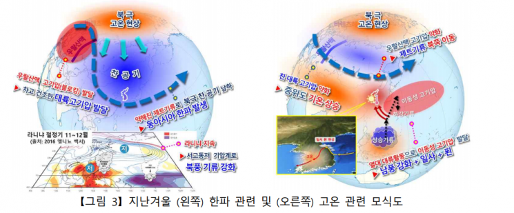
The cold wave that lasted from mid-December to early January was caused by the weakening of the jet stream due to Arctic warming. A warm air mass stagnated near the Ural Mountains, creating conditions that allowed cold Arctic air to descend more easily. Additionally, La Ni?a persisted in the tropical Pacific, leading to the development of a low-pressure system northeast of Korea.
When upward motion intensifies in the tropical western Pacific, downward motion intensifies near China and Mongolia, strengthening the cold continental high pressure in winter and intensifying the low pressure along Korea's northeast coast.
Abnormal high-temperature phenomena also appeared nationwide at the end of January and February. This was due to the combination of southern winds, strong sunlight, and the foehn effect. After mid-January, the warm air mass near the Ural Mountains weakened, and the center of cold air moved northeast, resulting in the lower atmosphere being influenced by warm mobile high pressure.
Elsewhere, over 70% of the mainland United States was covered with snow, and Texas experienced unprecedented heavy snowfall and cold waves, causing property damage exceeding 1 trillion won. In Taiwan, more than 100 people died due to Arctic-origin cold waves, with weather disasters occurring in various places.
Park Kwang-seok, head of the Korea Meteorological Administration, stated, "Last winter was a season in which rapid climate fluctuations occurred within the season, including severe cold waves, sudden heavy snowfalls, strong winds, and abnormal high-temperature phenomena," adding, "The Meteorological Administration will do its best to proactively provide weather disaster and climate analysis information closely related to the daily lives of the public."
© The Asia Business Daily(www.asiae.co.kr). All rights reserved.


