Establishment of Cloud-Based Spatial Information Data Integration and Convergence Utilization System
Enhancing Public Convenience in Spatial Information Use and Building a Foundation for Digital Land Realization
[Asia Economy Reporter Kangwook Cho] The Ministry of Land, Infrastructure and Transport announced on the 25th that it has successfully completed the first phase of the "Cloud-based Spatial Information Data Integration and Convergence Utilization System Establishment Project" aimed at improving the integration and utilization environment of national spatial information.
Since its establishment in May 2009, the National Spatial Information Center has served as a hub collecting and providing various national spatial information produced by 45 institutions and 73 information systems. However, the need for overall improvement has been raised due to management inconveniences caused by different system environments and separated operating equipment locations, as well as increased maintenance costs due to system aging.
Accordingly, the Ministry of Land, Infrastructure and Transport has been promoting the establishment of a spatial information convergence utilization foundation through a three-phase project from last year to next year, under the Cloud-based Spatial Information Data Integration and Convergence Utilization System Establishment Project.
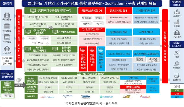
The cloud-based national spatial information integrated platform (K-GeoPlatform) established through this project provides a standardized national spatial information supply and service utilization environment.
The project aims to build an integrated database (DB) of national spatial information and improve quality through integration and data standardization on a cloud basis for national spatial information systems operated by the National Spatial Information Center, including Spatial Information Dream (2020), Land Information System, National Spatial Information Integration System (2021), and Korea Land Information System (2022).
The main contents of the recently completed first phase include ▲transition of computing resources to the cloud and replacement with open source ▲construction of an integrated DB and quality improvement through spatial information standardization ▲establishment of the spatial information development platform (K-GeoPlatform) and utilization services.
Nam Young-woo, Director of the Land Information Policy Division at the Ministry of Land, Infrastructure and Transport, said, "The importance of national spatial information is increasingly highlighted in the Digital New Deal and the Fourth Industrial Revolution, and spatial information should no longer be information unrelated to individuals but information that anyone can easily access and utilize. By establishing and sharing a cloud-based national spatial information convergence utilization system, it is expected to save about 90 billion KRW over the next five years (about 18 billion KRW annually), reduce the technical burden of building spatial information platforms, and serve as a foundation for creating various spatial information services."
© The Asia Business Daily(www.asiae.co.kr). All rights reserved.


