Snowfall every 5-6 days for 7.2 days until January 18
National average temperature at -3.1°C, the 9th lowest on record
[Asia Economy Reporter Han Jinju] In January, snow fell unusually frequently, and the average temperature was the ninth lowest on record.
On the 20th, the Korea Meteorological Administration (KMA) released weather analysis data stating that snow fell for 7.2 days over a 17-day period in the central region including the Seoul metropolitan area, occurring every 5 to 6 days. This is the highest record since weather observations began. The ranking may change when considering the entire month of January.
Cold air frequently moved southward, and warm, moist westerly winds were brought in by mobile high-pressure systems and troughs, causing frequent snowfall in the central region. During the process of atmospheric instability caused by the interaction of two different air masses, a lower-level jet stream, usually seen in spring and summer, accompanied the event, developing snow cloud bands up to an altitude of 4 to 5 km. These conditions were favorable for the growth of snow particles inside the clouds, resulting in a large amount of snowfall despite low precipitation.
The "maximum snow depth," which is the deepest snow accumulation observed during a set period, was 11.4 cm, ranking sixth highest.
 Positive Arctic Oscillation and Negative Arctic Oscillation (Data provided by Korea Meteorological Administration)
From the 1st to the 18th, the nationwide average temperature was minus 3.1 degrees Celsius, making it the ninth coldest on record. The highest temperature was 2.2 degrees Celsius, ranking ninth lowest, and the lowest temperature was minus 8.4 degrees Celsius, ranking eighth lowest. On the 6th, a cold wave warning was issued in Seoul for the first time in three years.
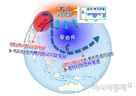
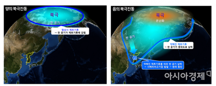
The frequent cold waves were largely due to the Arctic temperature rising and the jet stream weakening, resulting in a "negative Arctic Oscillation." The negative Arctic Oscillation refers to the phenomenon where the vortex of cold air over the Arctic fluctuates in strength over periods ranging from several days to decades. As a result, in the lower atmosphere, a continental high pressure developed northwest of Korea, and a low pressure system developed northeast of Korea, strengthening the cold northwesterly winds.
With La Ni?a persisting in the tropical Pacific, upward air currents (increased convective activity) strengthened in the western Pacific, and downward air currents (decreased convective activity) strengthened in the central Pacific, contributing to the development of low pressure northeast of Korea.
The KMA explained, "Compared to last year, when unusually high temperatures appeared amid frequent southward movements of cold air and low temperatures, this year saw frequent snowfall phenomena."
© The Asia Business Daily(www.asiae.co.kr). All rights reserved.


