Incheon Airport Begins Pilot Operation of Drone Defense System "SAWTOOTH" Since August
Detection Radar Capable of Detecting Up to 17Km... Already Deployed at 6 US Air Force Bases
[Monthly Defense Times Editor-in-Chief An Seung-beom] On September 26th, around 11:20 AM and 2:07 PM at Incheon Airport, five aircraft?including one passenger plane carrying 59 people and four cargo planes?were unable to land for about an hour due to illegal drone flights near Yeongjong IC on Incheon Bridge and in a park area within the Airport New Town. This was the first time since the airport's opening that takeoffs and landings were suspended for an hour due to the appearance of illegal drones in the surrounding airspace. Incheon Airport, a national security 'Grade A' facility, prohibits drone flights within a 9.3 km radius.
In September 2019, Saudi Arabian oil facilities halted operations after a drone attack, and in December, Chadwick Airport in the UK suspended aircraft operations due to illegal drone intrusions.
Such safety threats caused by illegal drones have now reached a very serious level. Recently, cases of drones being misused as terrorist tools have increased, making the detection and tracking of illegal flying drones critically important.
The military is also planning to acquire drone defense systems to prepare for various attacks using unmanned aerial vehicles and drones. The Defense Acquisition Program Administration announced in September 2019 that drone detection radars would be installed in the military’s scientific surveillance system, scheduled for completion by 2021, to overcome surveillance vulnerabilities at each unit and effectively block enemy infiltration and terrorist acts.
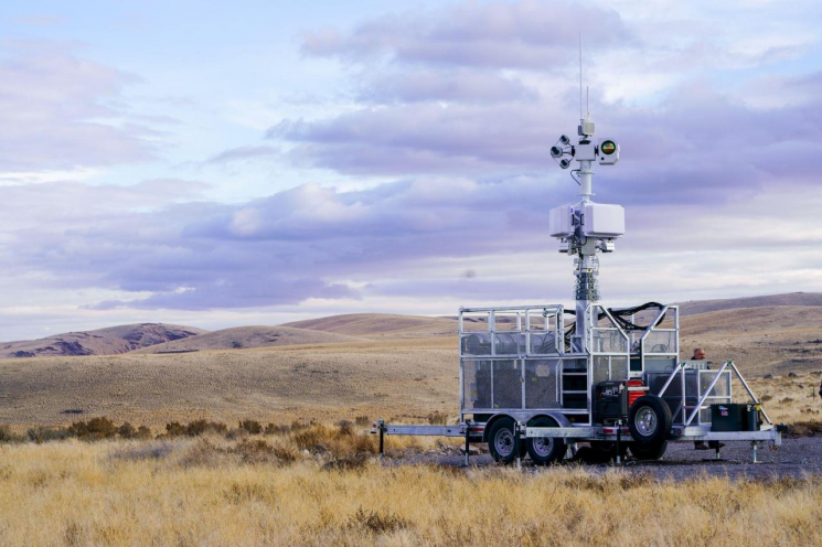
Currently, drone detection facilities are operational, enabling detection of drones flying up to 10 km radius around Incheon Airport. Since August, Incheon Airport has installed the drone defense system “SAWTOOTH” and begun pilot operations, with plans for future upgrades.
The SAWTOOTH system operating at Incheon Airport meets military standards used by six U.S. Air Force bases and NASA for illegal drone detection and countermeasures, and its adoption is expanding starting with Incheon Airport operations.
The radar and control equipment performance is adjusted according to the scale of defense, with radar capabilities and numbers tailored accordingly. The defense area is divided into warning, danger, and emergency zones, with control software managing detection and tracking distances as well as initial countermeasure distances. There are also fixed installations for basic defense areas, vehicle-mounted mobile types, and personal portable types.
The system components include an early warning radar providing target direction and early alerts, a tracking radar providing speed, altitude, and distance coordinates, EO/IR sensors, DEFEATOR (jammer), and control equipment. The Defeator (jammer) comes in personal portable and base-deployed types, and radars are divided into long-range and short-range types.
Regarding equipment specifications, the detection radar can detect up to 17 km, the tracking radar can track DJI Phantom drone targets with an RCS of 0.02㎡ up to 5 km, and the jammer can counteract various frequencies (WIFI 2.4, 5.8 GHz; GPS 1.57, 1.22 GHz; GNSS 1.6, 1.24 GHz; CELL GSM, LTE, UTMS; optional 433/915/800 MHz) automatically or manually up to 5 km. Radar detection and tracking distances are adjustable.
The control equipment software is an automated CUxS (Counter Unmanned xx Systems, various unmanned aerial attacks) kill chain system that sets defense zones, manages radar and jammer operations, and automatically classifies targets and performs video tracking upon detection. The software uses AI neural networks for precise identification.
In other words, it is trained to recognize new target data patterns and quickly determine the probability that a target belongs to one category or another, applying this in future identifications.
It instantly recognizes size, direction, latitude, longitude, speed, and acceleration patterns for humans, birds, drones, and unmanned aerial vehicles, distinguishing birds from drones. Since rotary-wing and fixed-wing aircraft share many similar flight characteristics that deterministic systems find difficult to differentiate, AI learns from changes in altitude, acceleration, and radar cross-section to identify them.
Additionally, receivers and transponders use onboard GPS to transmit latitude, longitude, altitude, direction, and unique identifiers once per second, exchanging ADS-B and MBSB track messages from remotely piloted aircraft, UAS, personnel, and vehicles.
Encryption uses HTTP tunneling and TLS with 128-bit or 256-bit AES encryption, allowing selective encryption of all video streams for video transmission over open or closed networks.
© The Asia Business Daily(www.asiae.co.kr). All rights reserved.


