Landfall near Ulsan South Coast around 9 AM
Strong Typhoon 'Kang'
Around 2 PM near East Sea off Gangwon
 At 9 AM, Typhoon Haishen No. 10 Notification (Provided by the Korea Meteorological Administration website)
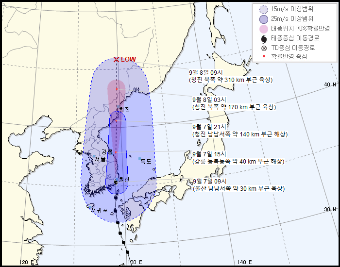
[Asia Economy Reporter Lee Hyun-joo] Typhoon No. 10 'Haishen' is expected to move northward, slightly shifted to the west of the predicted path.
According to the Korea Meteorological Administration, as of 9 a.m., Typhoon 'Haishen' is moving northward at 48 km/h about 30 km south-southwest of Ulsan on land.
With a central pressure of 955 hPa and maximum wind speed of 126 km/h, it has developed into a 'strong' intensity typhoon.
The typhoon's path has shifted somewhat westward compared to earlier predictions. Previously, the KMA forecasted that this typhoon would move northward along the East Coast without making landfall inland. A KMA official explained, "The typhoon moved closer to the coastline, causing a slight change in its path."
The typhoon that made landfall is expected to move northward close to the coast and exit into the East Sea off Gangwon around 2 p.m.
As the typhoon moves, very strong winds with maximum gusts of about 126 km/h are expected in the southern regions, and very heavy rain of around 50 mm per hour is expected in Gangwon Yeongdong and Gyeongbuk.
© The Asia Business Daily(www.asiae.co.kr). All rights reserved.


