Moving over Okinawa waters
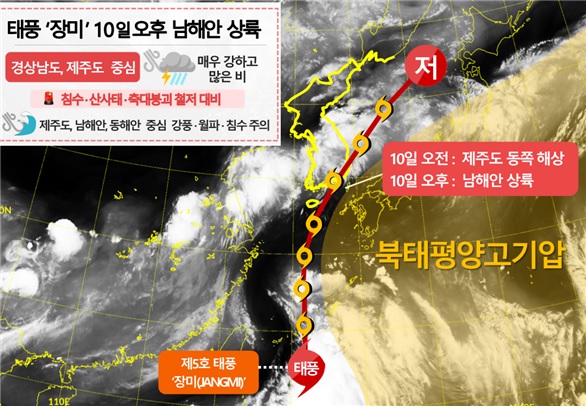
Advancing from South Coast to East Sea tomorrow
Very strong winds and heavy rain expected
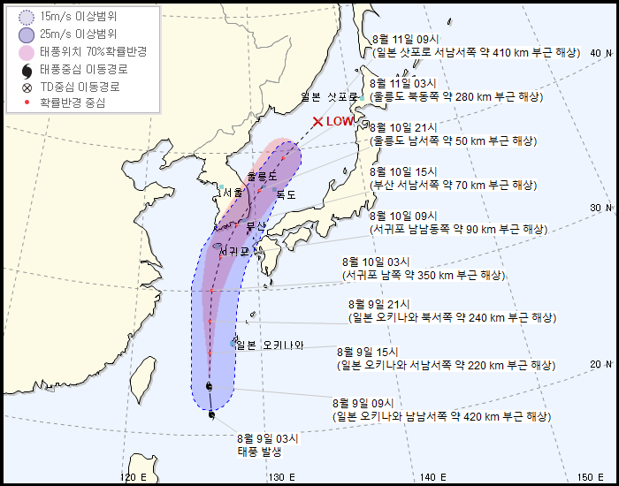
Possible low-pressure system change on the morning of the 11th
 Typhoon Expected Path from the 9th to the 11th and Expected Pressure Systems Around Korea (Provided by the Korea Meteorological Administration)
[Asia Economy Reporter Hyunju Lee] As Typhoon No. 5 'Jangmi (JANGMI)' moves northward, a large amount of rain is expected to fall nationwide once again.
The Korea Meteorological Administration announced that as of 9 a.m. today, Typhoon Jangmi, located about 420 km south-southwest of Okinawa, Japan, is moving north-northwest at a speed of 34 km/h. The central pressure is 1000 hPa, and the maximum wind speed is 65 km/h (18 m/s).
The typhoon, expected to pass east of Jeju Island on the morning of the 10th, is forecast to make landfall on the southern coast in the afternoon and then move out to the East Sea by night.
As the typhoon moves, heavy rainfall of up to 300 mm is expected in Jeju Island, Gyeongsangnam-do, and the area around Jirisan, which are closest to the typhoon's path. Additionally, the central region, where a stationary front remains, is forecast to receive up to 500 mm of heavy rain due to rain clouds accompanying the typhoon.
The typhoon, moving out to the East Sea by tomorrow night, is expected to gradually weaken into a low-pressure system by the morning of the 11th. However, the Korea Meteorological Administration explained, "Since the current strength of the typhoon is very weak, the timing of weakening into a low-pressure system may be earlier, and depending on changes in the pressure systems around Korea, the typhoon's path, speed, and landfall area are very variable."
© The Asia Business Daily(www.asiae.co.kr). All rights reserved.


