Calm on the 9th... Heatwave Advisory Issued for Gyeongsan, Daegu and Gyeongbuk
Gachang Dam and Gongsan Dam Exceed Full Capacity... Chilsunggyo Water Level Within Safe Range
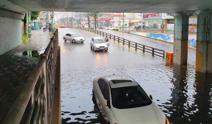 Due to the heavy rain on the 7th, traffic was completely blocked at Gyodong Gado Bridge (under the Gyeongbu Line railway bridge), Pyeonghwa Gado Bridge (under the Gyeongbuk Line railway bridge), and Jikji Bridge in Gimcheon-si, Gyeongbuk Province. A vehicle passing through Gyodong Gado Bridge was submerged in water.
[Asia Economy Yeongnam Reporting Headquarters, Reporter Park Dong-wook] On the 9th, rain showers in Daegu and the southern Gyeongbuk region will subside from the morning, and in the northern Gyeongbuk region, the rain will ease by evening. According to the Daegu Regional Meteorological Administration, the rain clouds are expected to resume from midnight on the 10th and expand across Daegu and the entire Gyeongbuk region by the morning.
According to Daegu City, the accumulated rainfall from the 7th until 5 a.m. on this day was 253.4mm in Hyomok-dong, Dong-gu, Daegu; 265.5mm in Dongin-dong, Jung-gu; 317.5mm in Jungri-dong, Seo-gu; 296.5mm in Chimsan-dong, Buk-gu; and 299.5mm in Hwawon, Dalseong-gun.
Due to the rain over two days, 32 hectares of farmland were flooded in six locations in Daegu, including 29 hectares in Hyeonpung-myeon, Dalseong-gun, as well as in Bakgok-ri, Dasa-eup, Maeho-dong, Suseong-gu, and Seoho-dong, Dong-gu.
Traffic has been restricted since the previous day on the 2.3 km section of the Sincheon-daero riverbed road between Gachanggyo and Beopwangsa, as well as on 0.45 km sections near the box culverts at the entrance of Nogok Village and at the entrance of Joya Village on Sincheon-daero. Additionally, 15 riverside parking lots along Sincheon, Wooksu Stream, Kumho River, and Nakdong River, and 32 stepping stones and submerged bridges remain closed to use.
By 4 a.m. on this day, the fire stations had received a total of 223 reports related to drainage issues (63 on the 7th and 160 on the 8th). As of 5 a.m., dam water levels exceeded full capacity: Gachang Dam (full capacity 140m) was at 140.3m, and Gongsan Dam (96m) was at 96.47m. The water level at Chilseonggyo was 0.96m at 5 a.m., surpassing the caution level of 0.85m, but it slightly decreased to 0.84m by 7 a.m.
In the Gyeongbuk region, heavy rainfall was recorded over two days (from the 7th to 6 a.m. on the 9th): 245.6mm in Seongju, 245.4mm in Gimcheon, 242.2mm in Goryeong, 311.50mm in Gimcheon (Daedeok), 293mm in Seongju (Surun), and 281mm in Goryeong (Gaejin).
Across Gyeongbuk, including 71.7 hectares of rice paddies and fields in Bonghwa-gun, a total of 145.74 hectares were submerged, with about 80% still flooded. Emergency repairs were carried out on eight roads, including a 40m section of Road 203 in Bongyang-ri, Surun-myeon, Seongju-gun, and on the embankment of Eum-oji (also known as Jang-oji) in Sinho-ri, Nakdong-myeon, Sangju-si, where some soil was washed away.
The Daegu Regional Meteorological Administration forecasts that heavy rain of 100 to 200mm may continue until the 10th in Daegu, Ulleungdo, and Dokdo, and until the 11th in northern and southwestern inland areas of Gyeongbuk.
Heavy rain warnings have been issued for Daegu and Pohang in Gyeongbuk, while heavy rain advisories are in effect for 15 cities and counties including Mungyeong, Cheongdo, Gimcheon, Chilgok, Gyeongsan, and Yeongcheon in Gyeongbuk. Heatwave advisories were also pre-announced from 11 a.m. on this day for Daegu and Gyeongsan in Gyeongbuk.
Im Ri-gyeong, a forecaster at the Daegu Regional Meteorological Administration, said, "The ground has weakened due to recent heavy rain," and emphasized, "Special caution is needed to prevent damage from flooding in low-lying areas, landslides, and retaining wall collapses."
© The Asia Business Daily(www.asiae.co.kr). All rights reserved.


