Goyang City Implements Digital Twin Across 268km²
Accelerating Future Industry Demonstrations Including Autonomous Driving and UAM
Launching 'Smart Administration' with 3D Architectural Reviews
Mayor Lee Donghwan: "Advancing to a Smart City with Digital Mapping"
Goyang Special City in Gyeonggi Province (Mayor Lee Donghwan) is accelerating its transformation into a smart city by building a 'high-precision electronic map' that allows for detailed observation of the entire city within a 3-centimeter margin of error.
On January 26, Goyang City announced that it had completed the construction of a high-precision electronic map with the highest resolution in Korea, covering the entire 268-square-kilometer area of the city. The city plans to fully utilize this map across all administrative sectors and future advanced industries.
The high-precision electronic map is based on a 1:1,000 scale digital topographic map and features detailed representations of major terrains such as roads, buildings, and rivers, as well as urban facilities like manholes, streetlights, traffic lights, and crosswalks. It contains approximately five times greater accuracy and six to nine times more information than the existing 1:5,000 digital maps, making it a valuable resource for enhancing administrative application and policy reliability.
The city plans not to limit this map to a one-time construction, but to continuously upgrade and update it, establishing a spatial information system that reflects urban changes in real time. This will serve as the foundation for smart city policies and advanced industry demonstrations.
3cm-Level Resolution, 268km² Coverage... Transitioning to a System that Reflects Urban Changes at All Times
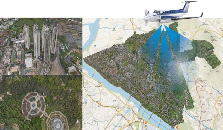
In March of last year, the city completed the construction of a high-precision electronic map with 3-centimeter resolution, covering the entire 268-square-kilometer area, with a total project cost of 6.8 billion won (50% national funding, 50% city funding). This project, selected through a nationwide public contest organized by the National Geographic Information Institute (Ministry of Land, Infrastructure and Transport), is based on a 1:1,000 scale digital topographic map and represents the highest level of spatial information in Korea.
Despite the complex urban environment, which includes extensive no-fly zones and the coexistence of first and third-generation new towns, the city achieved comprehensive coverage by combining drone and aerial photography. Using ultra-high-density LiDAR (Light Detection And Ranging) surveying, the city collected over 100 data points per square meter. By integrating 90,352 drone-captured images at 3-centimeter resolution and aerial photographs taken on 12 routes at an altitude of 2,760 meters, the city constructed spatial information closely resembling the actual city.
This year, the city will invest a total of 453.6 million won (50% national funding, 50% city funding) to further upgrade and update the high-precision electronic map. The city aims to immediately reflect rapidly changing urban environments, such as urban development, road maintenance, and new or expanded buildings, thereby maintaining the latest information and reliability and establishing a sustainable spatial information system.
 Completion report meeting for the High-Precision Electronic Map Construction Challenge Project held last March. Provided by Goyang Special City
From Public Land Management to Architectural Reviews... High-Precision Electronic Maps Applied to Administrative Sites
In June of last year, the city established a platform for utilizing high-precision electronic maps, and has since been using the data in various administrative fields.
Through the platform, the city compared and inspected land registers and registry records for public assets, identifying and correcting 1,377 discrepancies and 374 omissions, thereby improving the accuracy and efficiency of public land management.
Starting next month, the city will fully introduce a three-dimensional architectural review system based on the high-precision electronic map, enabling three-dimensional analysis of landscape, sunlight access, and view rights. Moving away from the previous review methods that relied on flat drawings and photographs, this system allows for a three-dimensional examination of the surrounding environment as if standing on the actual site, which is expected to enhance the objectivity and efficiency of decision-making.
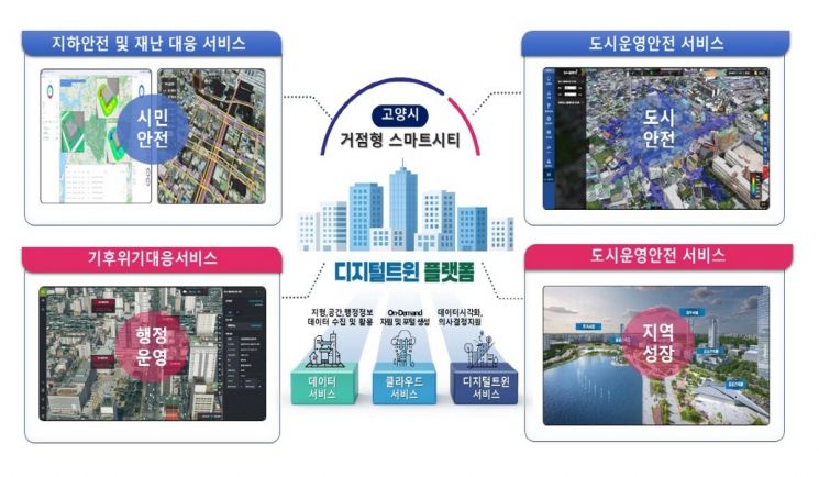
Additionally, the city plans to combine spatial information with digital twin technology to create a virtual space identical to the real city, and will gradually expand simulation analyses in areas such as transportation, environment, and disaster management. By implementing digital twin technology, which simulates various scenarios in a virtual city, the city will be able to pre-assess the effects and risks of policies, such as development project reviews, flood predictions, and ground subsidence analysis, before implementation.
Meanwhile, citizens can also access high-precision electronic map data free of charge. On the 'Gomap Digital Map Platform' (gomap.goyang.go.kr), which officially launched in October last year, users can check various city information, including urban planning, public facilities, and daily life information, based on three-dimensional spatial data.
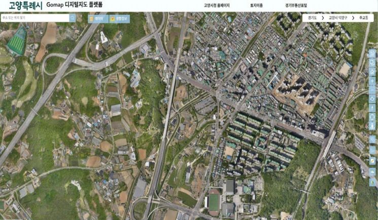 Goyang City's 'Gomap Digital Map Platform,' officially opened last October. Provided by Goyang Special City
Securing a Foundation for Autonomous Driving and UAM Demonstrations... High-Precision Electronic Maps Expanding into Smart Cities
Accurate spatial information is a core foundation for the demonstration of future industries such as autonomous driving and urban air mobility (UAM). Autonomous vehicles determine their routes based on information about lanes, signal systems, road structures, and surrounding facilities, while UAM secures flight paths and safety through analysis of three-dimensional urban structures. Without precise spatial information, such demonstrations are virtually impossible.
Building on this foundation, the 'Hub-Type Smart City Development Project' is also gaining momentum. With a total investment of 40 billion won (20 billion won from the national government and 20 billion won from the city), the project aims to establish ten smart services-including disaster response, transportation, and administration-by June this year.
The autonomous bus pilot project, the first of its kind in northern Gyeonggi Province, will begin test runs next month. During the day, the bus will circulate between Daehwa Station and KINTEX, and at night, it will operate between Daehwa Station and Hwajeong Station. Starting in April, there will be free pilot operations for citizens, followed by a gradual expansion.
Additionally, by June, a drone integrated control system will be installed at the Changjo Innovation Campus in Seongsa, and seven drone stations will be established throughout the city, including at Goyang City Hall and the Drone Anchor Center, to ensure the shortest dispatch routes in case of fires, floods, or wildfires.
Lee Donghwan, Mayor of Goyang Special City, stated, "The high-precision electronic map upgrade and renewal project is a core initiative for accurately recording and managing urban changes. By building precise spatial information, we will establish a foundation for the demonstration of advanced industries such as autonomous driving and urban air mobility (UAM), ensuring a seamless leap toward becoming a smart city."
© The Asia Business Daily(www.asiae.co.kr). All rights reserved.
![A Woman with 50 Million Won Debt Clutches a Stolen Dior Bag and Jumps... A Monster Is Born [Slate]](https://cwcontent.asiae.co.kr/asiaresize/183/2026021902243444107_1771435474.jpg)


