Google: "Requesting National Base Map, Not High-Precision Map"
Plans to Continue Consultations with the Korean Government
Google has expressed its intention to purchase satellite images of South Korea with sensitive areas masked, taking into account security concerns, ahead of the government's decision regarding the export of detailed domestic maps.
On August 5, Google emphasized on its official blog, "Google's mission is to organize the world's information and make it universally accessible and useful," adding, "Google Maps, one of our products that embodies this philosophy, helps users efficiently find directions and explore their surroundings based on the latest information."
Google went on to say, "In Korea, which attracts more than ten million foreign visitors every year, overseas tourists face inconvenience as soon as they arrive," identifying the reason as "because Google Maps' navigation feature is not available only in Korea." The company continued, "To resolve this inconvenience, we are working closely with the Korean government to enable this feature in Korea as well," and stated, "Recently, there has been some information that is not factual, and we would like to correct this," as it countered concerns about opposition to the export of maps.
Google clarified, "The map Google requested to export to the Korean government is not a highly detailed map such as 1:1000 scale, but the national base map at a 1:5000 scale," adding, "This data is already produced and freely distributed by the National Geographic Information Institute and has passed the government's security review, making it safe." The company also noted, "This is the same data used by most domestic map service providers, and Google Maps, which is serviced through SK's Tmap Mobility, is also based on this data." Regarding the possibility raised by some of using a 1:25,000 scale map, Google pointed out, "Such a map lacks sufficient information to provide detailed navigation in complex urban areas and is therefore not suitable for navigation purposes."
Regarding satellite images, Google stated, "The satellite images used in Google Maps are taken by various specialized companies and sold through open markets," and emphasized, "To most reliably mask sensitive security facilities, it is best to process these images at the source."
Google added, "Currently, in discussions with the government, we are seeking ways to mask sensitive facilities in Korea on the satellite images used in Google Maps," and stated, "We will continue to work with the Korean government to organize the world's information and make it universally accessible and useful."
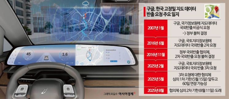
The government will hold a meeting of the 'Consultative Body on Survey Results and Overseas Export' on August 8 to discuss Google's request to export the 1:5000 scale detailed map. Although the consultative body postponed its decision at the meeting in May and extended the deadline by 60 days to August 11, it is highly likely that the decision will be postponed again due to the upcoming Korea-US summit.
Previously, Google also requested the export of maps in 2011 and 2016, but the government denied the requests, citing concerns that storing map data containing information on military bases and other security facilities on overseas servers could lead to information leaks.
© The Asia Business Daily(www.asiae.co.kr). All rights reserved.
![From Bar Hostess to Organ Seller to High Society... The Grotesque Con of a "Human Counterfeit" [Slate]](https://cwcontent.asiae.co.kr/asiaresize/183/2026021902243444107_1771435474.jpg)


