Heavy Rain Expected in Southern Regions Starting Tomorrow Afternoon
Another Heat Wave to Begin on Sunday
Heavy rain is expected to fall again, mainly in the central region, where record-breaking rainfall occurred last night.
According to the Korea Meteorological Administration, as of 11 a.m. on July 17, heavy rain warnings have been issued for certain areas, with intense rainfall of 20 to 60 millimeters per hour currently being recorded. From the evening, strong rain is expected as dry air moving southward behind a low-pressure system collides with hot and humid air being brought in by the northward expansion of the North Pacific High.
This bout of heavy rain is due to a trough approaching from the northwest of Korea, causing hot and humid air flowing in at the front to collide with cold and dry air descending at the rear, forming a mesoscale low-pressure system over the West Sea. From July 13 to 15, cold and dry air that had dominated the upper atmosphere over northern Korea, guided by a cut-off low, retreated slightly eastward, acting like a high-pressure system and compressing the rain clouds, which resulted in extremely heavy rainfall.
The rain will ease somewhat during the day on the 18th, but is expected to intensify again from the evening of the same day through the morning of the 19th. During this period, heavy rain is expected to be concentrated in the southern regions, where hot and humid air flowing in along the edge of the North Pacific High collides with the terrain.
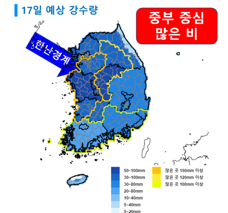
There may be times when rainfall reaches 50 to 80 millimeters per hour. The additional rainfall expected on July 17 is as follows: Chungcheong region, 50 to 100 millimeters (up to over 150 millimeters in the Chungnam area, and over 120 millimeters in the Chungbuk area); Seoul metropolitan area, inland and mountainous areas of Gangwon, and Jeonbuk, 30 to 100 millimeters (up to over 150 millimeters in southern Gyeonggi, central and southern inland Gangwon, and western Jeonbuk); Busan, Ulsan, Gyeongnam, Daegu, Gyeongbuk, and mountainous areas of Jeju, 30 to 80 millimeters (up to over 100 millimeters in Busan, Ulsan, Gyeongnam, and northern inland Gyeongbuk); Gwangju and Jeonnam, 20 to 80 millimeters (up to over 100 millimeters); the five West Sea islands, east coast of Gangwon, and Jeju (excluding mountainous areas), 5 to 40 millimeters; Ulleungdo and Dokdo, 5 to 20 millimeters.
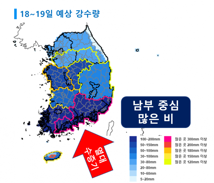
On July 18 and 19, Gwangju, Jeonnam, Busan, Ulsan, and Gyeongnam are expected to receive 100 to 200 millimeters (up to over 300 millimeters in southern coastal Jeonnam, Jirisan, Busan, Ulsan, and Gyeongnam); Chungcheong, 50 to 150 millimeters (up to over 180 millimeters in Chungnam); Jeonbuk and Jeju, 50 to 100 millimeters (up to over 200 millimeters in mountainous Jeju, and up to over 150 millimeters in Jeonbuk and in Jeju excluding the north and mountainous areas); Daegu and Gyeongbuk, 30 to 100 millimeters (up to over 120 millimeters); Seoul metropolitan area, inland and mountainous areas of Gangwon, 30 to 80 millimeters (up to over 120 millimeters in southern Gyeonggi and southern inland Gangwon); northern Jeju, 20 to 80 millimeters; Ulleungdo and Dokdo, 10 to 60 millimeters; and the five West Sea islands and east coast of Gangwon, 5 to 20 millimeters.
Starting Sunday, July 20, the North Pacific High is expected to completely cover Korea, bringing back hot weather. If the North Pacific High and the Tibetan High overlap over Korea, extreme heat waves may occur.
© The Asia Business Daily(www.asiae.co.kr). All rights reserved.

![Clutching a Stolen Dior Bag, Saying "I Hate Being Poor but Real"... The Grotesque Con of a "Human Knockoff" [Slate]](https://cwcontent.asiae.co.kr/asiaresize/183/2026021902243444107_1771435474.jpg)


