Planning Completed in Just 9 Months
Circular Pedestrian Green Network to Be Established
Landscape-Specialized Complex Designed with Elevation Differences in Mind
The area around 4 Beonji, Oryu-dong, Guro-gu is being reborn as a forest-adjacent complex with 1,250 households through rapid integrated planning.
On the 4th, the Seoul Metropolitan Government announced that it had finalized rapid integrated planning for the housing maintenance-type redevelopment project in the area around 4 Beonji, Oryu-dong.
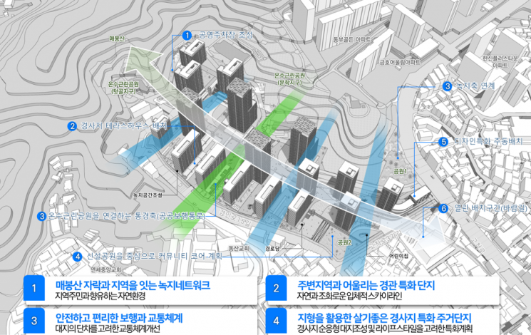
The target site is adjacent to Onsu Neighborhood Park and boasts excellent natural scenery, but has faced development difficulties due to constraints such as steep slopes. Considering these factors, rapid integrated planning was initiated in June last year, and after 15 expert review meetings, the planning has entered the completion stage within nine months.
Through this rapid integrated planning, the city plans to create a residential complex of about 25 floors and 1,250 households on an area of 55,977㎡.
Additionally, a circular pedestrian green network connecting the foothills of Maebongsan Mountain and the area will be established to improve park accessibility for local residents. To this end, a park will be placed along Gocheok-ro, and pedestrian routes and public walkways within the complex will be organically connected. Furthermore, a park will be arranged on the south side of the site, which has high accessibility to the surrounding low-rise residential areas, creating a shared space for local residents. A pocket park will also be created along Gyeongin-ro 15-gil, which connects to Onsu Neighborhood Park.
A landscape-specialized complex harmonizing with the surrounding area is also planned. Reflecting the characteristic of the site being a valley-type area surrounded by Maebongsan Mountain, building heights have been planned and a tent-shaped skyline conceptualized. Mid-to-low-rise buildings will be placed near the hilly areas and low-rise residential neighborhoods, while high-rise buildings will be located in the center of the complex, which is less affected by the surrounding areas. Specialized units with open terraces will be arranged along Gocheok-ro.
Efforts have also been made to improve pedestrian and traffic systems through road maintenance at the site. The city considered the site's characteristics, where access from Gocheok-ro, the main approach road, was inconvenient due to terrain differences. Taking into account the heavy traffic volume on Gocheok-ro, an additional lane was secured. Vertical circulation such as elevators and ramps were planned in sections with elevation differences.
Ways to enhance the usability of the complex by utilizing the terrain were also explored. First, taking advantage of the hilly terrain with a 35m elevation difference, architectural specialization plans such as terrace houses using the elevation difference and community facilities for residents were applied. Additionally, for user convenience, a multi-level public parking lot was planned underground on the north side of the complex adjacent to the park.
Jo Nam-jun, Director of the Urban Space Headquarters of Seoul City, said, "The target site completed planning within nine months after initiating rapid integrated planning through resident meetings and briefings," adding, "We plan to support the project so that it can proceed swiftly, reflecting residents' wishes."
Meanwhile, with this decision, 93 out of 164 rapid integrated planning sites in Seoul have completed planning.
© The Asia Business Daily(www.asiae.co.kr). All rights reserved.


