CCTV in China: "Aftershocks Possible for Several Days"
The death toll from the magnitude 7.1 earthquake that occurred on the morning of the 7th in the western Chinese Tibet Autonomous Region (Xizang) has risen to 95.
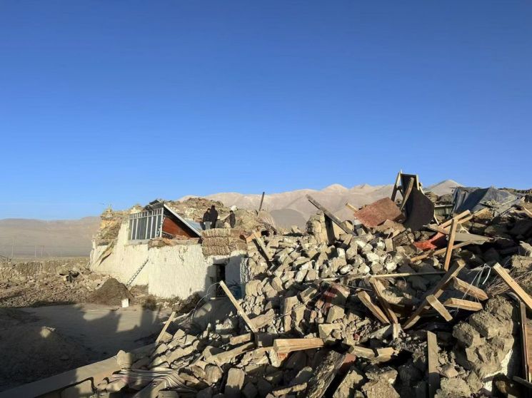 A village in the Tibet Autonomous Region of China affected by the earthquake. Photo by Reuters and Yonhap News.
The People's Government of Lhoka (Shigatse), the second largest city in the Tibet Autonomous Region, stated in a briefing that "According to the initial investigation as of 3 p.m. (local time), 95 people have died and 130 have been injured due to the earthquake in Dingri County, Lhoka City," adding, "The number of damaged houses is still being tallied."
With reports indicating at least 95 confirmed deaths and about 1,000 houses collapsed in the affected area, concerns are rising that the death toll may increase further.
According to the China Earthquake Networks Center, a magnitude 6.8 earthquake struck Dingri County, the second largest city in the Tibet Autonomous Region, at 9:05 a.m. local time. The focal depth was 10 km.
The United States Geological Survey (USGS) announced that at around 9:05 a.m., a magnitude 7.1 earthquake occurred in the Chinese region located 93 km northeast of Lobuche in the Nepal Himalayas. The European-Mediterranean Seismological Centre (EMSC) also reported a magnitude 7.0 earthquake at the same time, 99 km north-northeast of Lobuche and 202 km northwest of Darjeeling, India.
Following the earthquake, Chinese authorities have mobilized over 3,400 personnel including forest firefighters, armed police, public security, and military units, along with more than 150 vehicles and machinery, and about 340 medical staff to conduct rescue operations. Lhoka City explained, "Power supply has been cut off in Longsha Township, Dingri County, and there have been landslides in Chuolasan and Jacholasan districts," adding, "Rescue vehicles are able to pass through."
The earthquake's epicenter is located 34 km from Dingjie County, 36 km from Dingri County, 67 km from Lamu County, and 167 km from Lhoka City. It is 379 km away from Lhasa, the capital of the autonomous region. The epicenter is situated where the Indian Plate and Eurasian Plate collide, causing the uplift of the Himalayas.
China's state-run Xinhua News Agency reported that approximately 6,900 residents live within a 20 km radius of the epicenter. Additionally, the State Council Earthquake Response and Disaster Relief Command Office and the Ministry of Emergency Management have issued a national level 3 earthquake emergency alert and are conducting rescue and evacuation operations.
According to state-run China Central Television (CCTV), since the 1950s, there have been 21 earthquakes of magnitude 6 or higher in the Lhasa seismic zone, with the largest being a magnitude 6.9 earthquake that occurred in Milin, Tibet in 2017.
CCTV reported, "Generally, after a major earthquake, aftershock activity is observed in and around the epicenter area, and these aftershocks gradually decrease in intensity and frequency over time," adding, "There is a possibility of feeling tremors from earthquakes in the original and nearby areas in the coming days."
On the same day, Chinese President Xi Jinping stated, "A magnitude 6.8 earthquake in Dingri County, Lhoka, Tibet has caused significant casualties," and instructed, "We must use all efforts to search for people and rescue and treat the injured to minimize casualties and prevent secondary disasters."
© The Asia Business Daily(www.asiae.co.kr). All rights reserved.
![Clutching a Stolen Dior Bag, Saying "I Hate Being Poor but Real"... The Grotesque Con of a "Human Knockoff" [Slate]](https://cwcontent.asiae.co.kr/asiaresize/183/2026021902243444107_1771435474.jpg)


