Northeast Asian History Foundation's John Thomson Company Reveals 'World Waterways Map'
The Northeast Asian History Foundation announced on the 7th that it will exhibit the "World Hydrographical Map" created in 1817 by the British mapmaking company John Thomson at the Dokdo Experience Center.
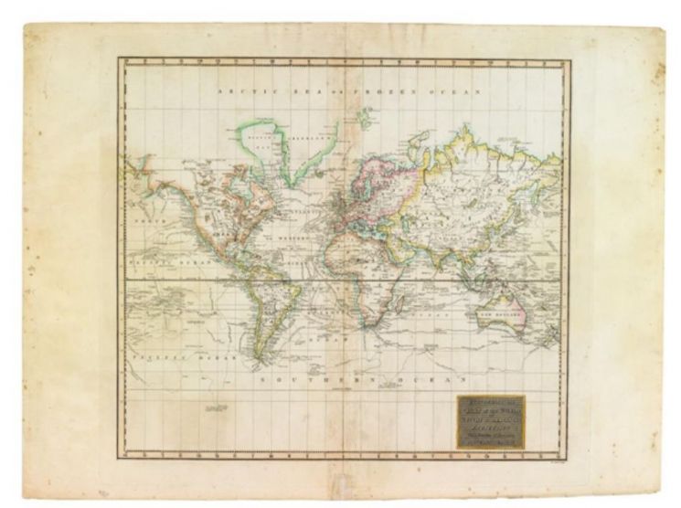
This map shows major global sea routes. It was included in John Thomson's publication, "A New General Atlas."
On the map, the name of Joseon is labeled as "Corea," and the East Sea area is marked as "Gulf of Corea." The Korea Strait is also recorded as "Str. of Corea." This indicates that the East Sea area was recognized as Korean waters.
The map features a line passing through the East Sea. The foundation explained, "It represents the route taken by the French explorer La P?rouse (1741?1788)." La P?rouse, who was also a French naval officer, circumnavigated the globe from 1785 to 1788 under the orders of King Louis XVI of France.
He and his expedition members became the first Westerners to witness Ulleungdo while sailing through the East Sea. They named Ulleungdo "D'Entrecasteaux Island" after the astronomer D'Entrecasteaux, who was the first among them to discover it.
The Dokdo Experience Center, operated by the foundation, is located on the second basement floor of Times Square in Yeongdeungpo-gu, Seoul. The exhibition runs until the 28th of next month.
© The Asia Business Daily(www.asiae.co.kr). All rights reserved.


