Naver officially launches a three-dimensional (3D) street view service based on spatial intelligence technology.
On the 16th, Naver announced the release of 'Street View 3D,' which allows users to view building and business information in a three-dimensional format within the street view.
This Street View 3D has been initially applied to major commercial areas within Seoul. It is currently available in districts such as Gangnam-gu, Mapo-gu, Songpa-gu, Yongsan-gu, Yeongdeungpo-gu, Jongno-gu, Jung-gu in Seoul, as well as Bundang-gu in Seongnam-si, Gyeonggi-do. The coverage area will gradually expand. Earlier in April, Naver Maps conducted a pilot test of Street View 3D in select areas like Gangnam and Bukchon in Jongno, Seoul, to test the technology and stability.
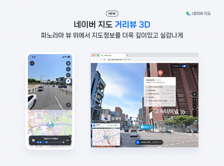
Naver Maps Street View 3D is a service that recreates offline spaces in a 3D environment, similar to viewing them with the naked eye. Naver stated that by incorporating diverse information of 3D spaces into the street view, it provides a richer and more practical service experience through smoothly connected panoramic views compared to the existing two-dimensional (2D) street view.
The most significant feature of Street View 3D is its support for three-dimensional place exploration and additional information, unlike the previous version which only allowed viewing simple images. Through Street View 3D, users can obtain detailed and three-dimensional information about businesses directly within the street view. It is also expected to be utilized for various new business opportunities within Naver Maps.
Additionally, various features have been added to enhance user convenience. Considering that users have mainly used street view to check entrances and parking lot entrances, these are now separately marked and detailed. In the PC environment, when a specific building is selected in street view, a highlight function distinguishes it from surrounding objects, allowing users to intuitively identify the building. Furthermore, Street View provides richer information than what is available on the map, such as lists of stores located within buildings.
Moreover, directional information based on signboards and landmark data is displayed to help users gauge directions at intersections. The 'Follow the Road' feature automatically plays routes on the street view as if moving along the road, enabling detailed offline location information verification. When selecting information about a business of interest, the service also connects to detailed information guides for additional insights.
Street View 3D has been advanced by integrating technology from Naver Labs. Notably, the P1 vehicle-based mapping system optimized for 3D data collection was utilized. Developed by Naver Labs' autonomous driving team, P1 synchronizes data collected from multiple sensors such as high-performance navigation sensors and LiDAR without error. The collected data is then processed using proprietary spatial intelligence technology, significantly improving the accuracy of spatial and object positioning compared to the existing street view. It also enables the 3D implementation of various information by adding depth data.
Choi Seung-rak, the leader overseeing Naver Maps services, stated, "The newly introduced Street View 3D is an advanced service aimed at providing map information closer to reality, and it allows for future expansion in various directions. We plan to evolve it into a more immersive map service by enabling users to check diverse information such as popular menu items of specific stores, discount coupons, and real-time congestion levels through Street View 3D, enhancing user convenience."
© The Asia Business Daily(www.asiae.co.kr). All rights reserved.
!["The Woman Who Threw Herself into the Water Clutching a Stolen Dior Bag"...A Grotesque Success Story That Shakes the Korean Psyche [Slate]](https://cwcontent.asiae.co.kr/asiaresize/183/2026021902243444107_1771435474.jpg)


