Global Goyang Smart City Based on Advanced Technology Kicks Off
Goyang Special City, Gyeonggi Province (Mayor Lee Dong-hwan) is set to present a new paradigm of location information based on advanced technology as the high-precision electronic map construction project enters its final stage.
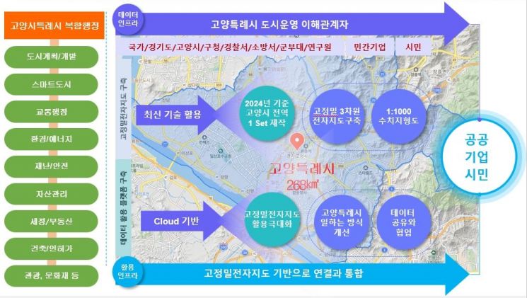
The high-precision electronic map construction project involves building and enhancing various three-dimensional spatial information, including 1:1000 scale topographic maps. It is a project carried out in partnership with the National Geographic Information Institute of the Ministry of Land, Infrastructure and Transport, with a 50:50 matching of national and local government funds, aimed at early completion of the digital twin, one of the national agenda items.
In particular, this project enabled the construction of more detailed and accurate spatial information data by capturing multi-layered location information using LiDAR, a cutting-edge technology gaining attention for acquiring three-dimensional location data, mounted on aircraft, drones, and automobiles.
The high-precision electronic maps constructed through this project are expected to serve as core data foundations in various fields such as digital twin, smart cities, and autonomous driving by integrating with the latest technologies like AI, big data, and cloud computing.
An official from the city stated, “We will continue to strive to provide innovative administrative services by linking the latest three-dimensional spatial information data based on digital twin with various municipal tasks through the construction of more accurate and reliable high-precision electronic maps.”
© The Asia Business Daily(www.asiae.co.kr). All rights reserved.

![A Woman with 50 Million Won Debt Clutches a Stolen Dior Bag and Jumps... A Monster Is Born [Slate]](https://cwcontent.asiae.co.kr/asiaresize/183/2026021902243444107_1771435474.jpg)


