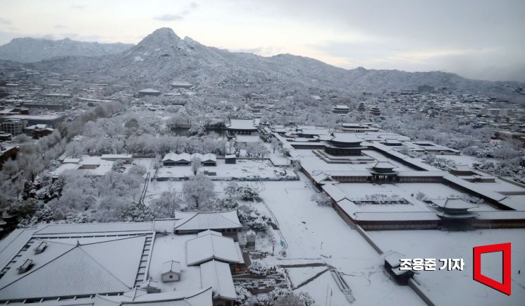
 On the 27th, when heavy snow fell across Seoul, snow accumulated on Gyeongbokgung Palace, the Blue House, and Bukaksan Mountain as seen from the Government Seoul Office in Jongno-gu, Seoul. Photo by Jo Yong-jun
On Thursday the 28th, except for the east coast of Gangwon, the central regions, eastern inland areas of Jeolla, inland areas of Gyeongbuk, and western inland areas of Gyeongnam are expected to experience heavy and wet snow falling at a rate of 1 to 3 cm per hour (around 5 cm in some areas) until the morning.
Most of the snow will stop by the morning, but rain or snow will continue until night in southern Gyeonggi, Chungcheong region, Jeolla region, and Jeju Island.
Over the two days of the 27th and 28th, the Seoul metropolitan area will see 5 to 15 cm of snow in Incheon and southern Gyeonggi, 3 to 8 cm (with some places exceeding 10 cm) in Seoul, northern Gyeonggi, and the West Sea Islands. Southern Gyeonggi may have places with snowfall exceeding 25 cm.
During the same period, Gangwon Province is forecasted to receive 5 to 15 cm (with some places exceeding 20 cm) in the central and southern inland and mountainous areas, 3 to 8 cm (with some mountainous areas exceeding 10 cm) in the northern inland and mountainous areas, and 1 to 3 cm along the east coast.
In the Chungcheong region, northern inland Chungnam and Chungbuk are expected to get 5 to 10 cm, while Daejeon, Sejong, and Chungnam will see 2 to 7 cm of snow. Central and northern Chungbuk may have places with snowfall exceeding 15 cm.
Other expected snowfall amounts include 5 to 20 cm in the mountainous areas of Jeju Island, 5 to 10 cm in the northeastern mountainous areas of Gyeongbuk, 3 to 8 cm (with some places exceeding 10 cm) in eastern Jeonbuk, 2 to 7 cm in northern inland Gyeongbuk and southwestern inland Gyeongbuk as well as western inland Gyeongnam, 1 to 5 cm in eastern inland Jeonnam and Ulleungdo and Dokdo, 1 to 3 cm in western Jeonbuk, and less than 1 cm in Daegu and central-southern inland Gyeongbuk.
Expected precipitation over the two days of the 27th and 28th is 5 to 30 mm in southern Gyeonggi and Jeju Island, 5 to 20 mm in Seoul, Incheon, northern Gyeonggi, West Sea Islands, inland and mountainous areas of Gangwon, Chungcheong region, and Jeolla region, and 5 to 10 mm in the east coast of Gangwon, western inland Gyeongnam, Daegu, Gyeongbuk, Ulleungdo, and Dokdo.
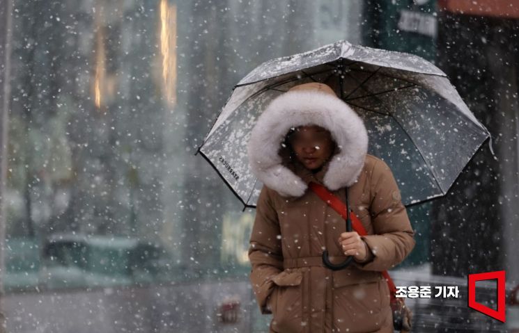 On the 27th, when a large amount of snow is falling nationwide including Seoul, a citizen dressed in thick clothing is walking in the snow on Dosan-daero, Gangnam-gu, Seoul. Photo by Jo Yong-jun
Strong wind warnings have been issued for Incheon and the western coast of Gyeonggi, Chungcheong region, Jeolla region, coastal areas of Gyeongsang region, northeastern mountainous areas of Gyeongbuk, and Jeju Island, with coastal areas and Jeju Island expected to experience very strong gusts reaching around 25 m/s.
The morning low temperatures will range from -5 to 6 degrees Celsius, and the daytime highs will be between 2 and 12 degrees Celsius, similar to or slightly lower than usual for this time of year.
Morning temperatures will drop below freezing in most parts of the country (below -5 degrees Celsius in inland and mountainous areas of Gangwon), and daytime temperatures will remain below 5 degrees Celsius mainly in the central regions. With strong winds, the wind chill will make it feel even colder.
Fine dust levels will be 'Good' nationwide due to favorable atmospheric dispersion and precipitation.
There may be thunder and lightning along with gusty winds mainly around the West Sea coast, so caution is advised for facility management and safety accidents.
Sea waves will be 1.0 to 2.5 meters in the East Sea nearshore, 1.0 to 4.0 meters in the West Sea nearshore, and 0.5 to 3.5 meters in the South Sea nearshore.
Wave heights in the outer seas (about 200 km from the coastline) are expected to be 2.0 to 4.5 meters in the East Sea, 2.0 to 5.5 meters in the West Sea, and 2.0 to 5.0 meters in the South Sea.
© The Asia Business Daily(www.asiae.co.kr). All rights reserved.
![User Who Sold Erroneously Deposited Bitcoins to Repay Debt and Fund Entertainment... What Did the Supreme Court Decide in 2021? [Legal Issue Check]](https://cwcontent.asiae.co.kr/asiaresize/183/2026020910431234020_1770601391.png)


