Mobile Map System to View Redevelopment and Reconstruction Projects at a Glance
Real-Time Access to Project Information Including Scale and Status by Project
Seoul City has developed a mobile map that allows users to view urban planning projects taking place across Seoul, including redevelopment, reconstruction, and Moa Town developments, all at a glance.
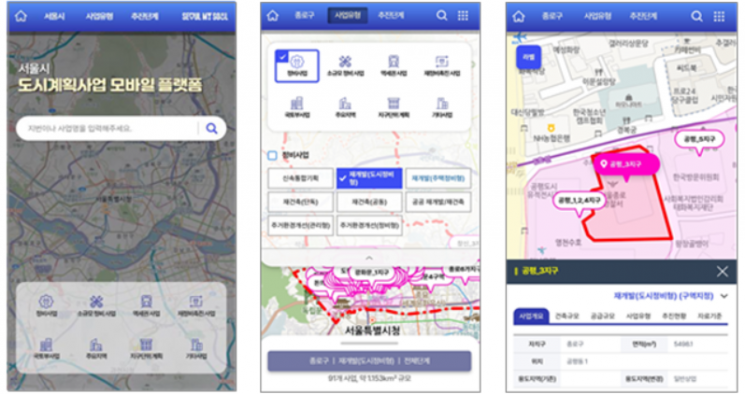
On the 12th, Seoul City announced that it is piloting the 'Urban Planning Project Mobile Map System' based on GIS (Geographic Information System). Currently, the system is being operated for city and district officials responsible for urban planning tasks, and a PC version will be developed in the future. After system stabilization, it is scheduled to be introduced to the public in the second half of next year.
Currently, information on Seoul's urban planning projects is scattered across city and district websites and the Jeongbi Project Information Mongttang platform, requiring users to visit multiple sites to access comprehensive data. The information types are also composed of images and complex materials, making it difficult to accurately analyze project locations and surrounding environments.
The city has unified the types of information provided and consolidated dispersed project data by district, project type, scale, and progress status into the Urban Planning Project Mobile Map System. By zooming in on the map and selecting a project, users can see the target area where the project is underway, as well as related data such as project type, scale, and progress status.
It is also easy to view when and how urban planning projects around a specific address have been progressing. Users can check urban planning projects by type, including △Rapid Integrated Planning △Urban Maintenance-type Redevelopment △Reconstruction (Joint) △Moa Town △Youth Safe Housing △Reorganization Promotion Projects (District/Preservation Maintenance/Preservation Management) △Housing Performance Improvement Support Zones, among others.
From April to July this year, as the first phase, the city built a database (DB) of 3,118 urban planning projects across 25 districts covering 15 types of projects. By the end of the year, it plans to establish a database of 3,653 urban planning projects covering 28 types in four pilot districts (Jongno, Yongsan, Gangseo, Songpa). In the future, the city aims to database the quantity, area, and progress stages of all urban planning projects in Seoul.
Jo Nam-jun, head of Seoul City's Urban Space Headquarters, said, "With the establishment of the Urban Planning Project Mobile Map System, we expect to perform more efficient and balanced 'field-centered urban planning work.'" He added, "We will continue to develop the system to provide stable services going forward."
© The Asia Business Daily(www.asiae.co.kr). All rights reserved.


