"Consideration of Drainage Issues and Characteristics of Humid and Soft Terrain"
Widening the Outer Channel in a Trumpet Shape to Slow Water Flow
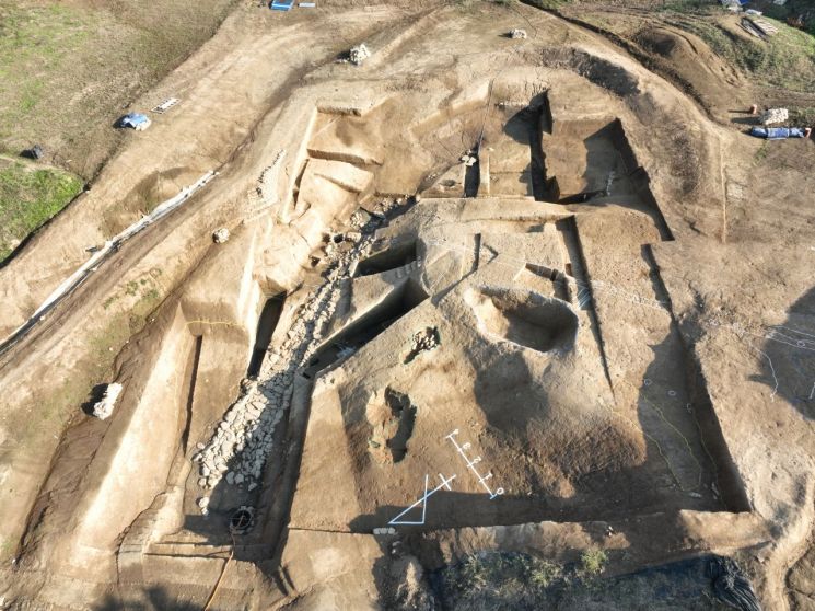
For the first time in the Gaya cultural zone ruins, a drainage system connecting the inside and outside of an earthen fortress was confirmed. The National Research Institute of Cultural Heritage of Gaya announced this finding on the 11th during the excavation of the Haman Gayari site.
The Haman Gayari site is presumed to be the royal palace of Ara Gaya. It is recorded as the site of an ancient kingdom in Joseon Dynasty historical documents such as the "Hamjuji (咸州誌·1587)" and "Dongguk Yeoji Ji (東國輿地志·1656)." Recognized for its historical value and significance, it was designated as a nationally protected cultural heritage site in 2019.
The institute has been conducting excavations since last year in the northwestern depression area. A depression is a narrow, sunken terrain where surrounding water naturally collects and drains.
The Gaya people blocked the narrow entrance of the depression and built fortress walls. They constructed the central earthen mound using the panchuk (compacted earth) technique and applied the buoyup method at the base to level the terrain inside the fortress.
An earthen mound is a defensive structure made by piling up soil into a ridge. Panchuk is an ancient civil engineering technique where wooden pillars are erected, and boards are connected between the pillars to form a rectangular frame, then soil is compacted layer by layer. It is used for building embankments or fortress walls. The buoyup method is a civil engineering technique used in low-lying or soft ground areas for embankments, fortress walls, or ground elevation works. Organic materials such as herbaceous plants and branches are laid at the base to reinforce the ground, aiding drainage, filtration, and preventing soil erosion.
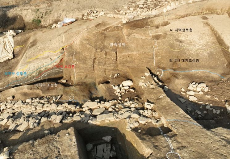
The Gaya people reinforced the fortress walls by constructing inner and outer walls with sloped, compacted soil layers inside and outside the panchuk earthen mound. The width of the panchuk mound was confirmed to be 5.5 meters, the base widths of the inner and outer walls were 12 meters each, and the total base width including the panchuk mound and inner and outer walls was 29.5 meters.
An institute official explained, "Considering internal drainage issues and the characteristics of the humid and soft terrain, the fortress walls and drainage system were constructed accordingly." They added, "Short-necked jars (dangyeongho) and cauldron-shaped pottery (bu-hyeong togi) were found within the ground elevation layers, suggesting a series of ritual ceremonies took place during the ground formation process."
The institute also confirmed that the drainage facility to discharge water collected in the depression inside the fortress passes through the fortress wall and leads outside. The drainage facility measures between 1.0 and 3.5 meters in width, with a remaining length of 16.5 meters. The section passing through the fortress wall was narrowed to about 1 meter in width to allow for covering stones to be placed, forming a culvert (amgeo, an underground channel).
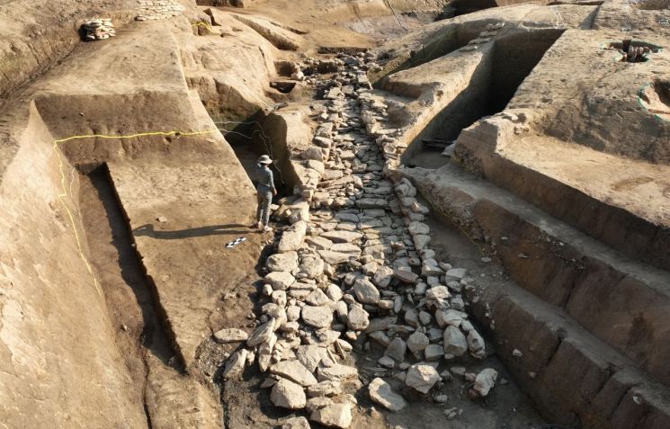
The part extending outside the fortress wall widens into a trumpet shape with a maximum width of 3.5 meters. It is identified as an open channel (gaegeo), without covering stones. An institute official explained, "The channel widens into a trumpet shape to slow down the flow of water," adding, "This is the first case discovered in the Gaya region."
The institute will hold a field briefing on the 13th to publicly share the excavation results. On the 20th, an academic symposium will be held at the Haman Museum to explain the latest investigation and research outcomes to local residents.
© The Asia Business Daily(www.asiae.co.kr). All rights reserved.


