Controversy Over JetBlue Airline Map Showing Palestinian Territory Above Jerusalem and Tel Aviv
Golan Heights Also Distorted... "Error Due to Enlargement"
A map displayed inside a JetBlue passenger plane, a low-cost American airline, showed the location of Israel labeled as 'Palestinian Territory,' causing some passengers to protest and create a commotion. On the 5th (local time), Israeli media Ynet reported, "Hodaya Knafo, an Israeli studying in the United States, recently felt puzzled while looking at the map on the personal screen in front of her seat on a JetBlue flight from Miami to San Diego."
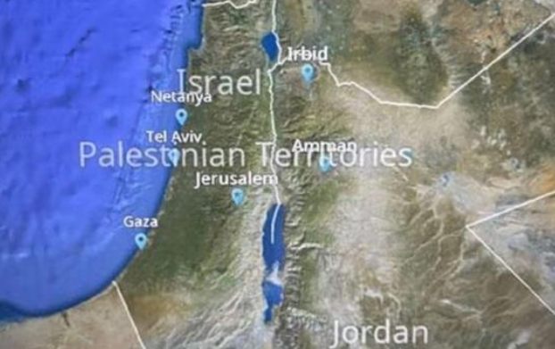
On the map, the name 'Israel' was written in the northern corner of the Israeli territory, while the phrase 'Palestinian Territory' was more prominently displayed over the central parts of Israel, including Tel Aviv and Jerusalem. According to the Oslo Accords, today's Palestinian territories consist of the West Bank and Gaza Strip. However, the West Bank, currently occupied by Israel, was not separately distinguished on this map, making it seem as if 'Palestinian Territory' did not correspond to the West Bank.
Additionally, the map drew Israel's borders excluding the northern Golan Heights occupied area, depicting the entire plateau as Syrian territory. Israel has effectively controlled a significant portion of the Golan Heights, which Syria held, since the 1967 Six-Day War. In other words, the map significantly distorted Israel's territory.
The way JetBlue's map was labeled also differs from Google Maps, one of the most widely used maps worldwide. On the Google world map, the label 'Palestine' does not appear over Israeli territory, and the Israeli-occupied part of the Golan Heights is marked with a dotted line.
The map is currently displayed identically on all JetBlue flights worldwide, including domestic flights within the United States, and has not been changed despite protests from some passengers. However, JetBlue responded, "It does not seem that the supplier has changed the map," adding, "There is a phenomenon where the font size changes when zooming in on the map." They further stated, "The map is used to check where the aircraft is flying, and we do not operate flights to Israel or the Middle East."
© The Asia Business Daily(www.asiae.co.kr). All rights reserved.
![User Who Sold Erroneously Deposited Bitcoins to Repay Debt and Fund Entertainment... What Did the Supreme Court Decide in 2021? [Legal Issue Check]](https://cwcontent.asiae.co.kr/asiaresize/183/2026020910431234020_1770601391.png)


