Presenting Weather News with a Hand-Drawn Map
"Feels Like Going Back to the 1970s"
On the 19th, a Microsoft (MS) outage caused various PCs and systems worldwide to shut down, leading to an amusing situation where a weather forecast was conducted using a hand-drawn map.
According to CNN on the 21st, KRCR, a CNN affiliate located in Redding, California, faced a situation on the 19th where they could not display the weather broadcast screen due to the global IT crisis.
Typically, weather forecasts are delivered by meteorologists standing in front of a green screen (a background for screen compositing) to present weather information. However, on this day, MS's PC operating system failure made it impossible to use the graphic software needed for the weather forecast.
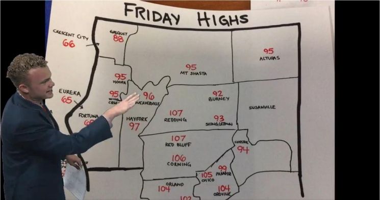
Upon discovering this situation during the morning commute, KRCR meteorologist Preston Donion proceeded with the broadcast by drawing a map of California on a large sheet of paper and marking place names and date information.
After the broadcast, Donion shared his weather forecast video on X (formerly Twitter), saying, "Trinity County looks like it has gone on a bit of a diet, and Modoc County has become a bit angular, but I wanted to provide you with visual information."
After the broadcast gained attention online, Donion explained, "At first, I tried to share information by displaying websites or screens on the station's iPad, but I realized this method was not very effective. I thought (the hand drawing) was the best way to convey the visual part without computer technology."
CNN meteorologist Elisa Raffa praised Donion's quick response. Raffa said, "Before the magic of the green screen was introduced, weather news was delivered like this. It’s just amazing how much we rely on technology."
One viewer mentioned that Donion's broadcast "felt like going back to the 1970s." According to CNN, in the 1970s, weather forecasts were actually conducted using paper maps and magnets.
© The Asia Business Daily(www.asiae.co.kr). All rights reserved.


