Naver Map Update... Enhancing Information Delivery
Detailed Classification and Grading of Various Accident Information
Naver announced on the 17th that it has rolled out a new update to Naver Maps, focusing on delivering detailed information about incidents occurring within users' living areas and enhancing disaster information guidance during navigation use.
Naver Maps has strengthened its guidance on various road-related hazards to support a safer travel experience in addition to user convenience.
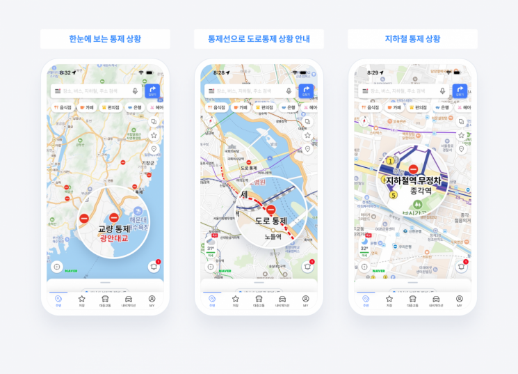
First, when incidents such as road closures, construction, traffic accidents, or disasters occur on roads, information is provided based on the administrative district of the user's registered home or workplace or current location. Additionally, various information is collected from administrative agencies, real-time news, and user reports, then summarized in card format for timely user access. These cards include details such as the status of major road and bridge closures due to accidents or disasters, as well as subway and train station service suspensions or delays.
Users can check the incident details and affected area information through the information cards, and can also directly observe the scene via representative closed-circuit television (CCTV) linked to the incident location. The detailed page provides specific incident descriptions along with start and end times. In the case of disaster incidents, links to Naver Encyclopedia’s disaster response guidelines are provided to assist users in their response.
Furthermore, Naver Maps has expanded its existing set of four icons (traffic control, accidents, construction, others) to seven by adding disaster alerts such as flood warnings, dam discharge notices, and large fire alerts. The redesigned icons are prominently displayed on the map to enhance visibility and allow users to intuitively recognize them.
Information on road and subway station closures, which previously required activation of the traffic information button on Naver Maps, is now provided by default. Controlled sections including bridges, tunnels, and underpasses are marked with red dotted lines on the map.
Additionally, during navigation route searches, areas with flood warnings and dam discharge alerts are pre-marked on the route guidance line to notify users. Unexpected situations during driving are also communicated to users in real time. Risk information along the route is displayed at the top of the mobile navigation screen, and voice guidance is provided when approaching or near incident locations or nearby accidents.
This update is a continuation of recent enhancements to Naver Maps’ user mobility support services. Previously introduced features include public transportation route guidance, Apple’s iOS Live Activity function that provides real-time public transit guidance without opening the app, and detour route guidance for users who have difficulty using stairs. A driving score feature that analyzes user driving records to score driving habits was also added.
As a result, the monthly active users (MAU) of Naver Maps’ public transportation and navigation functions have steadily increased, contributing to an overall rise in the app’s total MAU. In fact, the total MAU of the Naver Maps app was recorded to have increased by approximately 15% compared to last year.
Choi Seung-rak, the leader overseeing Naver Maps services, stated, "Unpredictable incidents threaten the safety of pedestrians and drivers, and the goal of this update is to enhance the delivery of traffic safety information provided by Naver Maps to help users prevent accidents, drive safely, and manage their schedules efficiently." He added, "Going forward, we plan to continuously advance Naver Maps as an 'all-in-one platform' that offers convenient and precise mobility experiences and supports users throughout their entire journey."
© The Asia Business Daily(www.asiae.co.kr). All rights reserved.
![Clutching a Stolen Dior Bag, Saying "I Hate Being Poor but Real"... The Grotesque Con of a "Human Knockoff" [Slate]](https://cwcontent.asiae.co.kr/asiaresize/183/2026021902243444107_1771435474.jpg)


