V-World, a national spatial information service platform, is being renewed as a 'Digital Twin National Land Platform' by enhancing user-centered utilization functions.
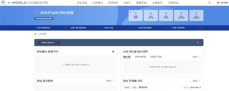 The newly established V-World 'My Portal' menu screen through the second phase advancement / Photo by Ministry of Land, Infrastructure and Transport
The Ministry of Land, Infrastructure and Transport announced on the 1st that it will start the second phase of V-World's advancement service from today. V-World is an open platform that provides spatial information held by the national government, local governments, and public institutions to the public. It offers six types of basic spatial information such as orthophotos and internet maps, as well as 949 types of administrative spatial information including continuous cadastral maps and land use district maps.
V-World aims to be a digital twin national land platform that implements the real world in virtual space, links it with administrative and attribute information, and solves various urban problems through simulation functions. Since last year, the Ministry of Land, Infrastructure and Transport has been carrying out a four-stage annual advancement plan reflecting user demands and the latest technologies according to the V-World advancement plan (2023?2026). The first phase of the advancement service was launched in August last year.
The main advancements this time include establishing a mobile utilization base, adding 3D analysis and simulation functions, transitioning to the cloud, opening a spatial information coordinator window, and launching a My Portal menu. First, to further strengthen user accessibility, a mobile utilization base was established to allow easy use of V-World on smart devices, and the open API was enhanced. A My Portal menu was also launched where users can register and manage data of interest in a customized way.
The basic digital twin national land function that allows virtual space simulations was also strengthened. To this end, analysis and simulation functions such as building aging analysis, hotspot analysis, and weather simulation were expanded. The functions increased from 9 in 3 fields (landscape, terrain, building) to 16 in 5 fields (landscape, terrain, building, weather, region).
An official application window for the 'Spatial Information Coordinator,' who professionally supports spatial information utilization, was also opened. Additionally, to handle large data volumes due to the expansion of 3D maps and for cloud-dedicated services (IaaS, SaaS), V-World's information resources were transitioned to a cloud environment. With this cloud transition, the Ministry explained that the service processing speed and service capacity have improved about twofold compared to before. Information resources can be flexibly expanded according to usage, ensuring system operation convenience and safety even when traffic surges.
Park Geon-su, Director of the National Land Information Policy Bureau at the Ministry of Land, Infrastructure and Transport, said, "We will steadily promote the advancement plan until 2026 so that V-World can leap forward as a representative digital twin national land platform that anyone can easily use without burden."
© The Asia Business Daily(www.asiae.co.kr). All rights reserved.


