Ministry of Land, Infrastructure and Transport Provides 58 Million KRW Each to Chungnam, Chungbuk, and Gyeongsan in Gyeongbuk
Spatial information projects in Chungnam, Chungbuk, and Gyeongsan, Gyeongbuk have been selected as outstanding projects of the year.
The Ministry of Land, Infrastructure and Transport announced on the 18th that projects such as Chungnam's "Digital Tidal Flat Information Construction and Utilization Project Using Drones and Artificial Intelligence (AI)," Chungbuk's "Mixed Reality and Augmented Reality: Digitally Drawing Chungbuk Cadastral Project," and Gyeongsan, Gyeongbuk's "Digital Twin Budget Map Service Construction Project" were selected as outstanding projects. There were 22 projects submitted this year.
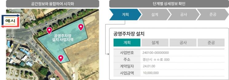 Example of the 'Digital Twin Budget Map Service Construction Project' in Gyeongsan, Gyeongbuk. [Image provided by the Ministry of Land, Infrastructure and Transport]
Chungnam's "Digital Tidal Flat Information Construction and Utilization Project Using Drones and Artificial Intelligence (AI)" is a project that extracts and constructs three-dimensional tidal flat information (such as tidal channels, fishing facilities, coastal hazards) analyzed by AI from drone footage, and utilizes it for simulations such as coastal flooding and facility management. A Ministry of Land official stated, "It is evaluated that this can be expanded to other local governments with tidal flats from the perspective of marine information management," adding, "In the future, this technology is expected to be widely used not only by local governments with tidal flats but also by other local governments."
Chungbuk's "Mixed Reality and Augmented Reality: Digitally Drawing Chungbuk Cadastral Project" is a project that constructs three-dimensional cadastral data using drones and visualizes land boundaries by linking with augmented reality (AR) equipment. A Chungbuk official said, "There were many complaints related to land boundaries due to differences between viewing boundaries on maps and in reality," and added, "This project will effectively resolve land boundary complaints."
Gyeongsan, Gyeongbuk's "Digital Twin Budget Map Service Construction Project" is a project that links spatial information systems with the next-generation local finance management system (e-Hojo+) to visualize the budget execution status of public projects such as SOC. Through this, information on budget input and execution is displayed on spatial information.
A Gyeongsan city official said, "When construction is carried out, it is now possible to see at once how the budget is used for facilities by integrating surveying information collected by the local government and the budget system." He added, "With the budget map service construction project, any citizen can see how much is invested in which facilities, which can reduce unnecessary construction."
The outstanding spatial information projects aim to discover and spread local government business models utilizing spatial information. The Ministry of Land will support each selected project this year with 58 million KRW in national funds.
Park Geon-su, Director of the Land Information Policy Division at the Ministry of Land, said, "We plan to continuously strive to commercialize and spread local governments' creative spatial information ideas."
© The Asia Business Daily(www.asiae.co.kr). All rights reserved.


