The National Institute of Forest Science is strengthening its research capabilities on forest disasters through organizational restructuring.
On the 26th, the Institute announced that it has renamed the Forest Disaster Research Department from the Forest Environment Conservation Research Department to the ‘Forest Disaster and Environment Research Department,’ and has carried out organizational restructuring including the establishment of the Landslide Research Division and the National Forest Satellite Information Utilization Center.
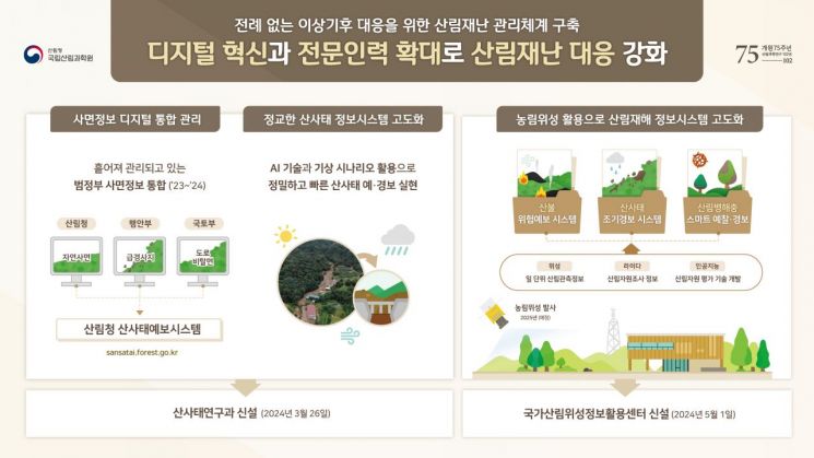
The organizational restructuring was conducted to support the government’s national agenda of ‘establishing an advanced disaster safety management system’ and to strengthen forest disaster research based on digital forest science technology.
The newly established Landslide Research Division will integrate and analyze slope data (including all slopes such as mountain slopes) that were previously managed separately by different ministries, improving the accuracy of landslide occurrence predictions and focusing its capabilities on preventing casualties and property damage caused by landslides during the monsoon season’s heavy rainfall.
Utilizing various disaster weather scenarios necessary for landslide prediction and responding to extreme rainfall will also be a primary mission of the Landslide Research Division.
The role of the National Forest Satellite Information Utilization Center, which will be established on May 1, is also noteworthy. The center’s core infrastructure is the Agricultural and Forestry Satellite. The satellite development project involves the Ministry of Science and ICT, the Korea Forest Service, and the Rural Development Administration. Korea Aerospace Industries (KAI) is in charge of overall satellite development, while the Korea Aerospace Research Institute (KARI) handles the payload.
The Korea Forest Service plans to complete a real-time, large-area forest management system in line with the Agricultural and Forestry Satellite launch schedule next year. The National Institute of Forest Science will lead the center to promote convergent forest disaster research using satellite technology, aiming to detect and respond to signs of forest disasters such as wildfires, landslides, and forest pests in real time.
By utilizing the Agricultural and Forestry Satellite, the current imaging cycle of the Korean Peninsula, which was 10 days last year (using foreign satellites), is expected to improve to 1 day, and the resolution is expected to become more precise from 10m range observation to 5m range observation.
The Institute will also increase its forest disaster research personnel from 25 to 44. In particular, it plans to focus on hiring experts in wildfires, landslides, forest pests, and satellite information, and to expand recruitment fields related to forest disaster research to include firefighting, geology, meteorology, and big data for convergent forest disaster research.
Jae-Soo Bae, Director of the National Institute of Forest Science, said, “The Institute will focus its research capabilities on protecting the safety of the public from forest disasters and conserving forests by utilizing advanced technologies such as big data, information and communication technology, and artificial intelligence.”
© The Asia Business Daily(www.asiae.co.kr). All rights reserved.


