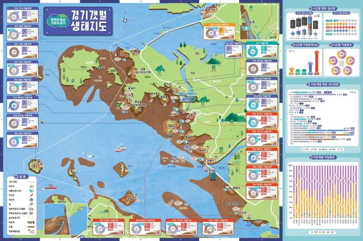
The Gyeonggi Marine and Fisheries Resources Research Institute has created the 'Gyeonggi Mudflat Ecological Map' to systematically manage the Gyeonggi mudflats.
According to the Marine and Fisheries Resources Research Institute, the total area of the Gyeonggi mudflats is 16,800 hectares, serving as a source of income for fishermen producing over 3,100 tons of shellfish annually. The mudflats play a significant role in creating marine ecosystems by purifying pollution and absorbing carbon.
However, due to large-scale development projects such as the Sihwa Lake reclamation project and climate change, changes in the mudflat ecosystem have occurred, leading to a sharp decline in the production of major shellfish like clams.
Accordingly, the Marine and Fisheries Resources Research Institute has been conducting direct surveys and literature reviews of the coastal mudflats in Gyeonggi Province since last year to produce the ecological map. The map contains various information including the ecology of the coastal mudflats in Gyeonggi, habitat information of useful shellfish, locations of fishing villages and protected areas, and newly appearing species.
Kim Bong-hyun, director of the Marine and Fisheries Resources Research Institute, stated, "Through the Gyeonggi Mudflat Ecological Map, we plan to systematically manage the mudflats and further promote their ecological value."
The institute plans to establish an integrated management system for the mudflats and utilize the ecological map as basic data for the restoration of mudflat resources.
© The Asia Business Daily(www.asiae.co.kr). All rights reserved.
![Clutching a Stolen Dior Bag, Saying "I Hate Being Poor but Real"... The Grotesque Con of a "Human Knockoff" [Slate]](https://cwcontent.asiae.co.kr/asiaresize/183/2026021902243444107_1771435474.jpg)


