Early Stage of Typhoon Development... Difficult to Predict Path
Rain Expected Nationwide Until the 30th
Starting from the 30th, the full-scale 'autumn rainy season' is expected to begin, while Typhoon No. 11 'Haikui' is moving northward around the Korean Peninsula. Although there are observations that it could directly affect the Korean Peninsula, it is difficult to predict the path as the typhoon is still in its early development stage.
According to the Korea Meteorological Administration on the 28th, Typhoon No. 11 'Haikui' formed at 9 a.m. that day, 570 km north-northwest of Guam. Haikui's central pressure is 998 hPa (hectopascal), and its maximum wind speed is 18 m/s (65 km/h). Moving northwest by west at 18 km/h, Haikui is expected to reach about 240 km west of Okinawa, Japan, by 3 p.m. on the 2nd of next month.
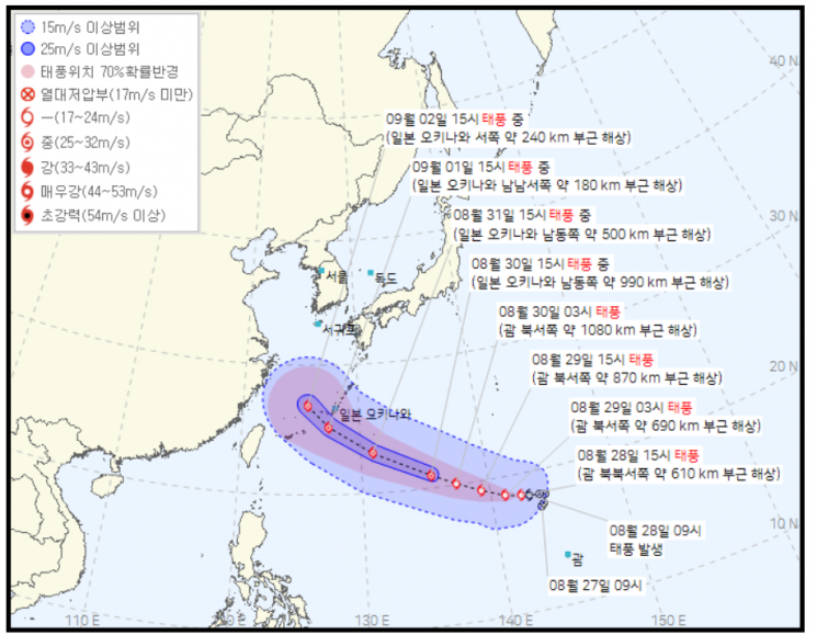
Meanwhile, Typhoon No. 9 'Saola' and Typhoon No. 10 'Damrey' are active simultaneously. Typhoon Saola is moving north at 14 km/h around 480 km northeast of Manila, Philippines, at 3 p.m. that day. This typhoon is classified as 'very strong' with a central pressure of 945 hPa and a maximum wind speed of 45 m/s (162 km/h).
Typhoon Damrey is moving northeast at 23 km/h around 490 km southeast of Sapporo, Japan, at 3 p.m. that day. It is a 'moderate' typhoon with a central pressure of 985 hPa and a maximum wind speed of 27 m/s (97 km/h). Damrey is expected to weaken into an extratropical cyclone by 3 p.m. on the 29th and approach about 1,270 km east of Sapporo, Japan.
The typhoon expected to have a direct impact on the Korean Peninsula is Haikui. Haikui is expected to move north to about 150 km southwest of Okinawa, Japan, on the 2nd of next month, but its path is difficult to predict.
The Korean Numerical Weather Prediction Model (KIM) predicts Haikui will move over the southern seas of Japan, but the European Centre for Medium-Range Weather Forecasts (ECMWF) model forecasts it moving toward Shanghai, and the UK Met Office Unified Model (UM) expects it to make landfall in southern China via Taiwan.
On the 28th, sporadic rain across the country will continue until the 30th. Expected rainfall until the 30th is 30-80 mm in the Seoul metropolitan area, the five western islands, Gangwon Yeongseo, Chungcheong, and Jeonbuk (with the five western islands exceeding 150 mm, Jeonbuk exceeding 120 mm, and northern Gyeonggi and northern Gangwon Yeongseo exceeding 100 mm), 50-120 mm in Jeonnam and Yeongnam (with eastern Jeonnam and western Gyeongnam exceeding 150 mm), 30-100 mm in Jeju (with Jeju mountainous areas exceeding 150 mm), and 20-60 mm in Ulleungdo and Dokdo.
Meanwhile, Haikui means 'sea anemone' in Chinese. Saola and Damrey refer to rare animals found in Vietnam and the word for 'elephant' in Khmer, respectively.
© The Asia Business Daily(www.asiae.co.kr). All rights reserved.
![User Who Sold Erroneously Deposited Bitcoins to Repay Debt and Fund Entertainment... What Did the Supreme Court Decide in 2021? [Legal Issue Check]](https://cwcontent.asiae.co.kr/asiaresize/183/2026020910431234020_1770601391.png)


