At around 9:20 a.m. on the 10th, Typhoon Khanun, the 6th typhoon of the season, made landfall in Geoje, Gyeongnam, and moved northward to near Daegu within three hours. Khanun changed its afternoon direction from 'north' to 'north-northwest,' slowing down further, which could prolong the period of heavy rain and wind in one area, raising concerns about greater damage.
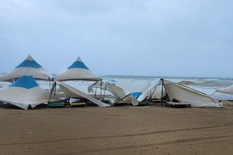
According to the typhoon information released by the Korea Meteorological Administration at 12 p.m. that day, Khanun advanced northward to about 20 km south of Daegu on land, moving north at a speed of 38 km/h. The central pressure and maximum wind speed are estimated at 980 hPa and 29 m/s, respectively. The intensity grade is 'medium,' one level lower than when it approached South Korea, but it is still strong enough to blow off roofs.
Currently, Khanun's northward speed is 38 km/h, but by 3 p.m., it will slow down to 23 km/h when it reaches a point about 60 km north-northwest of Daegu. After that, Khanun will move northward to about 10 km south-southwest of Chungju by 6 p.m. at a speed of 27 km/h, and by 9 p.m., it will reach about 30 km southeast of Seoul, increasing its speed to 29 km/h before changing its direction to north-northwest and slowing down again.
Because of this, when Khanun reaches about 40 km north of Seoul at midnight on the 11th, its speed will drop to 20 km/h, and after entering North Korea, Khanun will maintain a speed of around 15 km/h. As Khanun moves slowly in North Korea, it will pour heavy rain over the inter-Korean border area, potentially causing floods in the lower reaches of shared rivers such as the Imjin River and Hantan River.
Meanwhile, as Khanun made landfall, typhoon warnings were issued nationwide as of 11 a.m. that day. In Gangwon Yeongdong, Gyeongbuk, and eastern Gyeongnam, rainfall is between 30 to 60 mm per hour; in Chungnam, Jeonbuk, and the southern coast of Gyeongnam, 10 to 30 mm per hour; and in other regions, around 10 mm per hour.
The Korea Meteorological Administration forecasts that heavy rain of 40 to 60 mm per hour will continue in Gangwon Yeongdong, the Gyeongsang coast, western inland Gyeongsang, and eastern Jeolla, while other areas will see around 30 mm per hour. In particular, Gangwon Yeongdong may experience 'extreme heavy rain' with up to 100 mm per hour, and western inland Gyeongbuk may see 60 to 80 mm per hour. Rain will gradually subside in Jeju and the southern regions by night, but precipitation will continue in the central regions until the 11th, and in the northwestern part of Gyeonggi in the central region until early morning on the 12th. Khanun will reach North Korea by early morning on the 11th, but the cloud band behind it will continue to bring rain to the central regions.
Strong winds with maximum instantaneous wind speeds of around 145 km/h (40 m/s) will blow along the eastern coast of Jeonnam and the Gyeongsang coast until the 11th. Gangwon Yeongdong, inland Gyeongsang, Honam (excluding the southeastern coast of Jeonnam), the western coast of Chungnam, and Jeju will experience maximum instantaneous wind speeds of 90 to 125 km/h (25 to 35 m/s). Incheon, the western coast of Gyeonggi, southern inland Gyeonggi, Gangwon Yeongseo, and inland Chungcheong will see 70 to 110 km/h (20 to 30 m/s), while Seoul and northern inland Gyeonggi will have winds reaching 55 to 90 km/h (15 to 25 m/s).
© The Asia Business Daily(www.asiae.co.kr). All rights reserved.


