Professor Hosaka Yuji, Interview with Kim Eo-jun
Old Japanese Textbooks' Maps Do Not Show Dokdo
"It's a Lie That Dokdo Was Originally Marked as Japanese Territory"
[Asia Economy Reporter Ryu Jeong-min] "(In 1929) This is a Japanese textbook, and the Government-General of Korea also used this..."
Professor Hosaka Yuji, Associate Professor at Sejong University and Director of the Dokdo Comprehensive Research Institute, appeared on the YouTube broadcast "Kim Eo-jun's Humility is Difficult News Factory," hosted by broadcaster Kim Eo-jun, on the 20th, revealing a textbook containing a Japanese map from 1929. Japan claims that Dokdo has originally been marked as Japanese territory, but the book contained content that overturns this claim.
Historically, Japan's claim that Dokdo is its inherent territory is not longstanding. Professor Hosaka Yuji showed the Japanese textbook and explained, "This is a history map textbook. In Korea, there are social studies maps and such textbooks, right? The content learned in social studies is historically made into maps."
 Associate Professor Yuji Hosaka of Sejong University appeared on "Kim Eo-jun's Humility is Difficult News Factory" on the 20th and revealed a Japanese textbook from 1929.
 [Photo by Kim Eo-jun's Humility is Difficult News Factory YouTube broadcast screen capture]
Like Korea's social studies maps, various maps of Japan are included. It is known that Professor Hosaka Yuji obtained the material from a monk at Misongsa Temple in Jinju, Gyeongnam. It is a textbook used by Japan in 1929, which had been kept until now, and thinking it might be related to Dokdo, the Director of the Dokdo Comprehensive Research Institute, Professor Hosaka Yuji, was asked to assess the content.
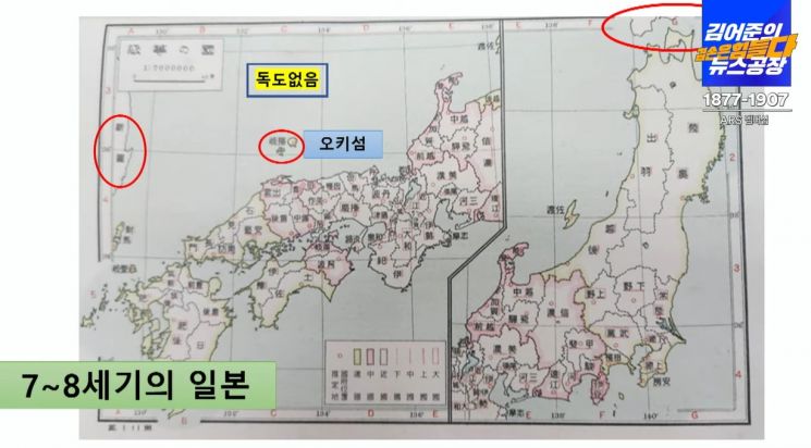
Professor Hosaka Yuji explained, "Maps from the 7th to 8th centuries continue to appear," and "The closest Japanese island to Dokdo, Oki Island, is marked, but Dokdo is not marked at all." If Japan had originally marked Dokdo as its territory, it should have been marked along with Oki Island, but Dokdo was absent.
Professor Hosaka Yuji said, "There are maps from the 7th and 8th centuries, then from the 8th to 13th centuries during the Japanese period, maps from the 14th century, and maps from the 15th century Sengoku period, and all are the same," adding, "Looking at maps from different eras, Dokdo is not marked."
Professor Hosaka Yuji stated that Japan's claim that it has always marked Dokdo as Japanese territory is a lie. He said, "The claim of inherent territory itself cannot be accepted, and this is the first time materials proving that are being disclosed."
Professor Hosaka Yuji added, "The closest Edo period maps are the same. Even in the Edo period, Dokdo was not marked."
 Associate Professor Yuji Hosaka of Sejong University appeared on "Kim Eo-jun's Humility is Difficult News Factory" on the 20th and revealed a Japanese textbook from 1929.
 [Photo by Kim Eo-jun's Humility is Difficult News Factory YouTube broadcast screen capture]
Professor Hosaka Yuji analyzed that Dokdo is marked on a 1905 Japanese map, but this was intended to emphasize the naval victory in the Russo-Japanese War. He explained, "In 1905, when fighting the Russian Baltic Fleet, the map shows exactly where in the East Sea the battles with Russia took place," and "The tenth and final battle was off the coast of Dokdo, where Japan completely defeated the Baltic Fleet."
From Japan's perspective, it was a victorious naval battle, and the claim is that Dokdo was marked on the map to convey that situation. Professor Hosaka Yuji said, "Dokdo first appears on maps in 1905," emphasizing, "Japan's original thought about Dokdo was military purpose."
The claim that Japan originally marked Dokdo as its territory is false; rather, it means that Japan asserts Dokdo as its territory for the purpose of promoting the place of glory during the militaristic era, emphasizing the victory in the 1905 naval battle against Russia.
© The Asia Business Daily(www.asiae.co.kr). All rights reserved.


