Hinnamnor Develops to 'Super Strong' Then Lands in Seogwipo as 'Very Strong'
Lands in Busan at 9 AM on the 6th with Central Pressure of 950hPa, Stronger than Typhoon Maemi
50-100mm Hourly Rainfall in Seoul Metropolitan Area, Western Gangwon, and Northern Chungnam from the 5th
Strong Winds of 40-60m/s from Night of the 5th in Jeju, Southern Coast of Jeonnam, and Coastal Gyeongnam
Over 600mm Rainfall in Jeju Mountains by the 6th, 400mm in Northern Gyeonggi, Western Gangwon, and Southern Coast Areas
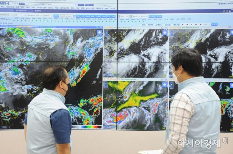
[Asia Economy Reporter Han Jinju] Typhoon Hinnamnor, the 11th typhoon of the year, will pass through the Korean Peninsula on the 5th and 6th. It will re-intensify as it moves northward, and its strength at the time of landfall on the Korean Peninsula is classified as 'very strong.' It will make landfall with a central pressure stronger than that of 'Sarah' or 'Maemi,' which caused the greatest damage in history.
According to the Korea Meteorological Administration (KMA), Hinnamnor is currently moving northward 390 km northeast of Taipei, Taiwan, with a current intensity of 'very strong.' However, by 3 a.m. on the 5th, when it reaches 480 km northeast of Taipei, its intensity will increase to 'super strong.' 'Super strong' refers to maximum wind speeds of 54 m/s or higher, while 'very strong' refers to wind speeds between 44 m/s and less than 54 m/s.
Typhoon Hinnamnor Makes Landfall on Korean Peninsula with Unprecedented Power
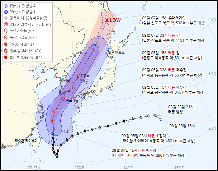
When Hinnamnor reaches 340 km south-southwest of Seogwipo City, Jeju, its intensity will slightly weaken to 'very strong,' and it will maintain 'very strong' intensity as it passes 50 km northeast of Seogwipo City at 3 a.m. On the 6th at 9 a.m., it is expected to make landfall 20 km north-northwest of Busan with an intensity classified as 'strong,' a central pressure of 940 hPa, and maximum wind speeds of 43 m/s.
Typhoon Hinnamnor has a very low central pressure and is large enough to cover the Korean Peninsula, so it is expected to have a strong impact. Among typhoons that have affected Korea, Typhoon Sarah recorded a central pressure of 941.4 hPa in Busan on September 17, 1959, and Typhoon Maemi recorded 954.0 hPa in Tongyeong on September 12, 2003. The lower the central pressure of a typhoon, the stronger the vortex and the more powerful the typhoon is classified.
Forecaster Lee Kwang-yeon explained, "Hinnamnor will approach the Korean Peninsula with 'very strong' intensity, maintaining its strength until it experiences friction with the ground and passes through cold water areas that cause energy loss by rainfall. The Tibetan high pressure system to the west remains strong, and the North Pacific high pressure has somewhat contracted, opening a path for the typhoon to move northward. Additionally, warm and humid water vapor from the Indian Ocean and the South China Sea supports its re-intensification."
Heavy Rainfall on the 5th and 6th...600mm in Jeju Mountains, Over 400mm in Northern Gyeonggi and Gangwon Yeongseo
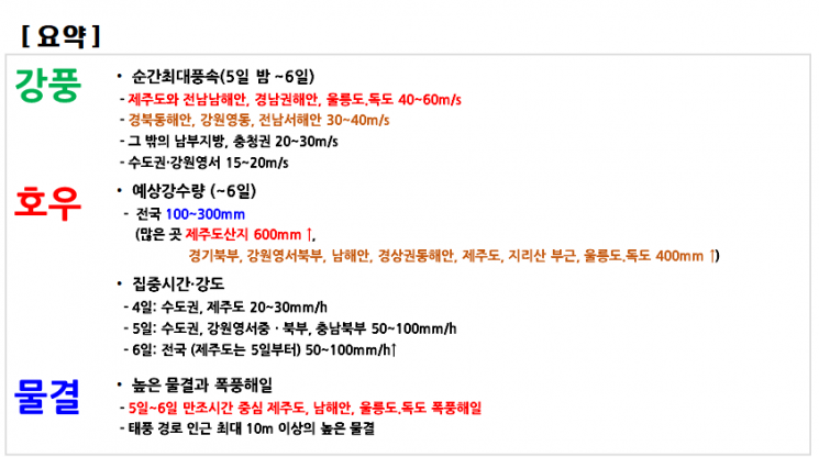
The KMA announced that by the 6th, more than 600mm of rain will fall in the mountainous areas of Jeju Island, and over 400mm in northern Gyeonggi, northern Gangwon Yeongseo, the southern coast, the eastern coast of Gyeongsang Province, Jeju Island, near Jirisan, and Ulleungdo and Dokdo. Expected rainfall in most other regions nationwide is between 100 and 300mm.
The period of intensified rainfall will be on the 5th and 6th. On the 4th, the Seoul metropolitan area and Jeju Island will experience rainfall of 20-30mm per hour. From the 5th, the Seoul metropolitan area, central and northern Gangwon Yeongseo, and northern Chungnam will see rainfall of 50-100mm per hour, and on the 6th, heavy rain at the level of 50-100mm per hour will fall nationwide.
Heavy rain will fall not only in the southern regions directly affected by the typhoon but also in the central regions, with totals reaching up to 400mm. This is due to a pressure trough developing south of Mongolia, which brings cold and dry air from the northwest converging with warm and humid water vapor moving northward from the south, leading to the development of strong rain cloud bands. The collision point of these two different air masses is the central region, where the rain cloud bands develop very high and strong, resulting in very heavy and intense rainfall. Especially in the central region, heavy rain will be concentrated from the night of the 5th to the morning of the 6th, when the cloud bands associated with the typhoon meet.
The KMA issued heavy rain advisory warnings on the night of the 4th for Incheon (Ganghwa), Paju, Yeoncheon, and Gimpo in Gyeonggi Province. From the early morning of the 5th, the advisories will expand to Hwacheon and Cheorwon in Gangwon Province, and from the morning of the 5th, to Seoul, northern mountainous areas of Gangwon, Inje plain, Yanggu plain, Chuncheon, Hongcheon plain, and all of Gyeonggi Province.
Forecaster Lee said, "The central region will experience heavy rain due to the convergence zone, while the southern region will be greatly affected by the typhoon itself. The pressure trough and the cloud bands accompanying the typhoon are expected to merge from the 5th to the first half of the 6th, causing heavy rain nationwide. This will not only bring a large amount of rain but also expose the area to strong winds."
Typhoon Advisory Warnings Gradually Expanded...Jeju, Southern Coast, Gyeongsang Region, Jeonbuk, etc.
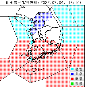
On the morning of the 5th, the KMA issued typhoon advisory warnings for Jeju Island, the seas in front of Jeju, the southwestern outer sea of the South Sea, the eastern outer sea of the South Sea, the southern outer sea of the southern West Sea, and the southern inner sea of the southern West Sea. From the afternoon, the warnings will expand to Gwangju, Namhae and Tongyeong in Gyeongnam, Jeollanam-do, the eastern outer sea of the southwestern South Sea, the seas in front of the southwestern South Sea, the eastern inner sea of the South Sea, the seas in front of the eastern South Sea (western Namhae sea in Gyeongnam), the northern inner sea of the southern West Sea, and the seas in front of the southern West Sea.
From the night of the 5th, typhoon advisory warnings will be issued for Ulsan, Busan, Daegu, Gyeongsangnam-do (excluding Namhae and Tongyeong), Gyeongsangbuk-do (Gimcheon, Seongju, Goryeong, Cheongdo, Gyeongsan), Jeollabuk-do, and the seas in front of the eastern South Sea (eastern seas of Geoje City, central Namhae sea in Gyeongnam, seas in front of Busan).
Between the night of the 5th and the 6th, when the typhoon approaches, extremely strong winds that make it difficult to stand will blow, so going outside should be avoided. In Jeju Island, the southern coast of Jeollanam-do, the coastal areas of Gyeongnam, and Ulleungdo and Dokdo, the maximum instantaneous wind speed is forecast to be 40-60 m/s. On the eastern coast of Gyeongbuk, Gangwon Yeongdong, and the western coast of Jeollanam-do, wind speeds of 30-40 m/s are expected. Other southern regions and Chungcheong Province will experience 20-30 m/s, and the Seoul metropolitan area and Gangwon Yeongseo region will see 15-20 m/s.
Wind speeds of 17 m/s make walking difficult, 25 m/s can uproot trees, and wind speeds of 44 m/s or higher can blow away people or large rocks. According to KMA statistics, during Typhoon Maemi on September 12, 2003, maximum instantaneous wind speeds of 60 m/s were recorded in Gosan and Jeju.
Jeju, the southern coast, Ulleungdo, and Dokdo must also prepare thoroughly for storm surges. A storm surge warning is expected to be issued centered around high tide times from the 5th to the 6th. During the period when sea levels rise on the 5th and 6th, waves as high as 10 meters are expected near the typhoon's path.
Forecaster Lee urged, "The low pressure at the typhoon's center raises the sea surface, and when this coincides with high waves, the water level rises further, causing coastal lowlands to suffer from flooding and other damage. Therefore, prior preparation is necessary."
© The Asia Business Daily(www.asiae.co.kr). All rights reserved.


