Seocho-gu Selected as the Only Seoul District in Ministry of Land, Infrastructure and Transport's 'Digital Twin Pilot Project Contest'; 1-Year Pilot Project Worth 1.4 Billion KRW (700 Million KRW National, 700 Million KRW District Funds) to Start in October & 24-Hour Traffic Volume Analysis, Monitoring Traffic Condition Changes from Data Office & Banpo-dong Area near Express Bus Terminal Chosen as Pilot Site for Future Traffic Measures Development
[Asia Economy Reporter Jongil Park] Seocho-gu (District Mayor Seongsu Jeon) is introducing ‘Digital Twin’ to solve the chronic traffic problems in the Gangnam area. This innovative smart administration creates a twin 3D traffic model of reality in a virtual space, simulates it, and then uses the data obtained to formulate actual traffic measures.
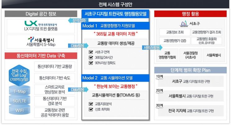
Digital Twin refers to a technology that implements real objects identically as 3D models in a virtual world, supporting various decision-making by applying analysis, prediction, and optimization based on simulation.
To this end, the district applied for the ‘Digital Twin Land’ pilot project hosted by the Ministry of Land, Infrastructure and Transport last July and was the only autonomous district in Seoul selected. In this application, the district presented a ‘Traffic Simulation Model Using Digital Twin’ plan, proposing efficient solutions such as traffic demand forecasting and signal optimization, which was recognized for its high potential for use by local governments nationwide in the future.
Through this selection, the district will receive 700 million KRW in national funding and conduct the pilot project with a total budget of 1.4 billion KRW, including 700 million KRW from the district. The project will run for one year starting in October, with technical support from the Korea Land and Geospatial Informatix Corporation (LX).
The main feature of the ‘Traffic Simulation Model Using Digital Twin’ conducted by the district is that it collects traffic volume by utilizing mobile communication data from vehicle users, overcoming temporal and spatial limitations, and allows accurate analysis by viewing the data through 3D simulation.
The traffic volume collection method based on communication data has secured over 90% accuracy as part of the Ministry of Land, Infrastructure and Transport’s ITS innovation project in 2021.
Previously, investigating traffic flow on major roads in the area required deploying a large number of personnel and video equipment on-site for each case. With this simulation system, traffic volume collection and analysis can be conducted 24 hours a day from an office monitor without additional personnel.
The big data obtained through this process can be implemented in S-Map after consultation with Seoul City, allowing precise understanding of changes in traffic conditions in the surrounding areas including the target region, and optimal traffic signal systems can be derived. This can be reflected in decision-making during traffic impact assessment reviews.
S-Map is a 3D platform integrating Seoul’s spatial information developed by Seoul City, used to promote the practical application of Digital Twin.
For example, when discussing policy directions for the demolition of some overpasses in Seocho-gu, using the district’s traffic simulation allows real-time analysis of traffic volume, traffic demand forecasts, and traffic conditions before and after road demolition, enabling scientific and rational decision-making in future traffic impact assessment reviews.
This model also enables more accurate traffic impact assessments, playing a key role in establishing efficient traffic policies such as traffic infrastructure investment. The police can obtain optimized signal operation methods, and citizens can receive high-quality traffic services.
The district selected the area around Banpo-dong Han River and Seoul Express Bus Terminal as the pilot application area for this traffic simulation model. Currently, 42 reconstruction projects are underway in this area, and various traffic demands are expected to surge. Additionally, the area includes nationwide traffic-inducing facilities such as Seoul Express Bus Terminal and department stores, and major arterial roads connecting regions such as Gyeongbu Expressway, Olympic-daero, and Han River bridges (Dongjak, Banpo, Hannam Bridge, Jamsu Bridge) pass through, so traffic congestion is expected to worsen continuously.
The district plans to apply the Digital Twin technique to this area, analyze traffic changes and wide-ranging traffic flows before and after reconstruction completion, and prepare traffic measures based on accurate data. It is expected that successful execution will help provide assistance for traffic measures nationwide.
Assemblywoman Eunhee Cho, whose constituency includes this pilot area, said, “Seocho-gu’s ‘Digital Twin Land Traffic Impact Assessment Support Model Development’ is expected to produce solutions to severe traffic congestion around the Gyeongbu Expressway and the Express Bus Terminal. We will spare no government-level support for the traffic measures established in this way.”
Seocho District Mayor Seongsu Jeon said, “I am very pleased that our district can contribute to the Ministry of Land, Infrastructure and Transport’s Digital Twin expansion policy. This project is expected to become a national traffic expert,” adding, “We will develop the system well so that Seocho-gu’s Digital Twin traffic solution becomes the answer to traffic problems in local governments nationwide.”
© The Asia Business Daily(www.asiae.co.kr). All rights reserved.


