Available for Download on the Land Information Platform
The National Geographic Information Institute announced on the 20th that it will provide free services of maps for color vision deficiency users on the National Geographic Information Platform starting from the 21st.
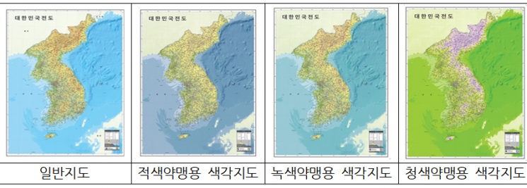
Maps for color vision deficiency users are maps created by converting colors so that people with color vision deficiency can easily distinguish various colors representing transportation, water systems, vegetation, cycles, and more.
Color vision deficiency refers to the inability to perceive certain colors or distinguish them from others due to congenital dysfunction or acquired damage of the retinal cone cells. The most common type is green weakness, followed by green blindness, red blindness, red weakness, and blue weakness.
The service targets three maps: the Map of the Republic of Korea, the Surrounding Map of the Republic of Korea, and the World Map. In the future, the target maps will be expanded to include On-Map and others. On-Map is an electronic document (PDF) format map produced by the National Geographic Information Institute that allows users to add or delete desired information on the map without any additional application.
Sagong Hosang, Director of the National Geographic Information Institute, said, "We expect that maps for color vision deficiency users will help them obtain accurate spatial information," and added, "We will expand the production of spatial information for socially disadvantaged groups such as visually impaired people who have been excluded from the use of spatial information."
By accessing the National Geographic Information Platform website, anyone can use various spatial information services produced by the National Geographic Information Institute, including various maps, aerial photographs, control points, and place name information.
© The Asia Business Daily(www.asiae.co.kr). All rights reserved.
!["I'd Rather Live as a Glamorous Fake Than as a Poor Real Me"...A Grotesque Success Story Shaking the Korean Psyche [Slate]](https://cwcontent.asiae.co.kr/asiaresize/183/2026021902243444107_1771435474.jpg)


