30~50mm per hour in Seoul Metropolitan Area and Gangwon Inland/Mountain Areas
Over 150mm in Northern Gyeonggi and Northern Gangwon
Mostly clear, humid, and hot on the weekend with heatwaves and tropical nights
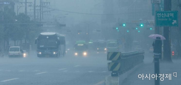 Due to the influence of the monsoon front, a heavy rain warning was issued for the Seoul metropolitan area on the 30th, and a vehicle near Jeungsan Bridge in Seoul is creating a spray of water. Photo by Kang Jin-hyung aymsdream@
[Asia Economy Reporter Han Jinju] From the 7th to the 8th, heavy rain will fall in the metropolitan area and inland/mountainous regions of Gangwon Province, and over the weekend, high humidity combined with heatwaves will cause sweltering heat to prevail.
On the 6th, the Korea Meteorological Administration held an occasional briefing and forecasted that a long cloud band moving from west to north-south will bring heavy rain accompanied by thunder, lightning, and gusts of wind, with rainfall rates of 30 to 50 mm per hour, mainly in the metropolitan area and northern Gangwon region from the afternoon of the 7th to the early morning of the 8th.
The rain cloud band is expected to develop twice between the afternoon of the 7th and the early morning of the 8th. Over the two days, up to 150 mm of rain is expected in northern Gyeonggi and northern Gangwon Yeongseo regions, and about 30 to 100 mm in the metropolitan area and northern Gangwon. Rainfall of about 10 to 60 mm is expected in the Chungcheong region, southern regions, Jeju mountainous areas, and the five western islands. In the southern regions, showers will occur due to strong southwesterly winds and topographical effects.
Woo Jin-gyu, a forecast analyst at the Korea Meteorological Administration, said, "On the 7th, strong rain cloud bands will form in the metropolitan and northern regions as air converges between low and high pressure systems, while in the southern regions, southwesterly winds and topographical effects will sporadically develop strong rain cloud bands in mountainous areas, resulting in varying rainfall patterns by region."
He added, "Although strong rain cloud bands will form locally during the rainfall and move northeastward, the duration of the rain cloud bands will be short, but due to strong southerly wind flows, the time for the rain cloud bands to move out will be slow."
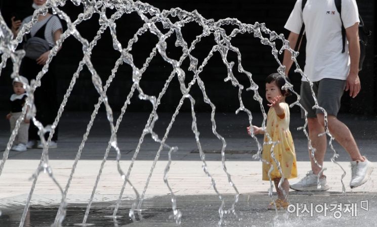 On the 1st, after the monsoon rain stopped and the heat intensified, a child was playing in the ground fountain at the National Museum of Korea in Yongsan-gu, Seoul. According to the Korea Meteorological Administration, the monsoon is expected to subside over the weekend and holidays, with scorching heat taking over instead. Photo by Kim Hyun-min kimhyun81@
Over the weekend, the heat will return with daytime heatwaves and tropical nights at night. Locally, showers may occur during the day. Forecast analyst Woo Jin-gyu explained, "Dry air will flow into the upper atmosphere over the weekend, and humid air and water vapor in the lower atmosphere will significantly increase the perceived temperature," adding, "After showers, evaporation causes water vapor to rise in the atmosphere, raising the perceived temperature."
After the 11th, the stationary front is expected to become active again, bringing heavy rain. Nationwide rain is expected once on the 11th and 12th, followed by a lull, and then rain is expected in the central regions from the 13th. The hourly rainfall intensity will be strong, and the slow movement of clouds requires preparation for damage caused by heavy rain. However, there is significant uncertainty about where the stationary front will form, so the areas of concentrated rainfall should be monitored through future forecasts.
Forecast analyst Woo said, "A stationary front will form as dry air flows into Korea from the north and hot, humid air rises from the south, causing the air masses to collide," and analyzed, "A strong rain cloud band that is long east-west and narrow north-south will become active from early next week."
© The Asia Business Daily(www.asiae.co.kr). All rights reserved.
![Clutching a Stolen Dior Bag, Saying "I Hate Being Poor but Real"... The Grotesque Con of a "Human Knockoff" [Slate]](https://cwcontent.asiae.co.kr/asiaresize/183/2026021902243444107_1771435474.jpg)


