[Asia Economy Reporter Ryu Tae-min] The Ministry of Land, Infrastructure and Transport and the Korea Land and Geospatial Informatix Corporation announced on the 27th the urban planning status statistics for 2021, which include data on urban area population and size, zoning districts, zones, areas, and urban and county planning facilities.
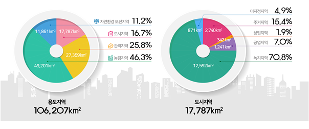
The area of land designated as zoning districts was 106,207 km², of which urban areas (residential, commercial, industrial, and green areas) accounted for 17,787 km², approximately 16.7% of the total area. Among the total registered population of 51.64 million, 47.4 million people (91.8%) were found to reside in urban areas.
Outside urban areas, management areas covered 27,359 km² (25.8%), agricultural and forest areas 49,201 km² (46.3%), and natural environment conservation areas 11,861 km² (11.2%). Urban areas were divided into residential areas 2,740 km² (15.4%), commercial areas 342 km² (1.9%), industrial areas 1,241 km² (7.0%), green areas 12,592 km² (70.8%), and undesignated areas 871 km² (4.9%).
Compared to 2020, residential areas (26.7 km²), industrial areas (18.9 km²), and commercial areas (3.6 km²) in urban areas increased, while green areas decreased by 30.0 km². In non-urban areas, management areas increased by 49.0 km², whereas agricultural and forest areas decreased by 54.8 km² and natural environment conservation areas decreased by 8.9 km². These changes are believed to be due to adjustments in urban and county management plans.
Development permits totaled 275,211 cases, a 10.4% increase compared to 2020. Among these, 'building construction' accounted for 164,965 cases (59.9%), followed by 'landform changes' with 67,431 cases (24.5%). By province, Gyeonggi-do had the highest number of development permits at 73,564 cases, and by zoning district, management areas had the most development permits at 69,205 cases.
The area designated for urban and county planning facilities totaled 7,032.3 km², a 4.4% increase from 2020. Transportation facilities (2,258.7 km²) were the largest, followed by disaster prevention facilities (2,155.1 km²) and spatial facilities (1,200.8 km²).
The annual urban planning status statistics are used as a basis for urban policy and planning formulation as well as for calculating local government grants. Detailed data can be accessed through the Land Use Regulation Information System or e-Nara Indicators.
© The Asia Business Daily(www.asiae.co.kr). All rights reserved.


