Polar Research Institute Successfully Produces 3D Video
[Asia Economy Reporter Kim Bong-su] Domestic researchers have succeeded in capturing video footage of the aftermath of the most powerful volcanic eruption in Tonga since the 20th century.
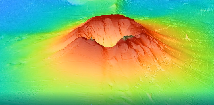
The Korea Polar Research Institute announced on the 25th that it deployed the icebreaker research vessel Araon to produce 3D video data showing the terrain changes following the Tonga volcanic eruption. The results showed that compared to before the eruption, the central part of the volcano was more deeply depressed, but the overall shape had not changed significantly.
The Hunga Tonga-Hunga Ha’apai volcano, located 65 km northwest of Tongatapu Island in the Kingdom of Tonga, erupted on January 15 of this year. It is estimated to be the most powerful volcanic eruption since the 20th century, and as a result, 91% and 75% of Hunga Tonga Island and Hunga Ha’apai Island, respectively, which were located on top of the volcanic body, disappeared. A new 700-meter-deep hole, four times the size of Yeouido, was created, and the central depth, which was 150 meters, dropped to 820 meters. However, the walls around the caldera formed by the collapse of the central part due to the eruption were confirmed to have remained intact without collapsing.
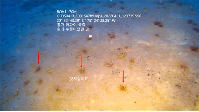
This was contrary to expectations that the strong eruption would make it difficult to recognize the original shape. A New Zealand research team also introduced a similar interpretation to foreign media on the 23rd and 24th. The Korea Polar Research Institute deployed the icebreaker research vessel Araon, which was returning to Korea after the 2021-2022 Antarctic voyage, to the site of the Tonga volcanic eruption. From April 8, the team conducted an on-site survey for about ten days and secured exploration data to create a topographic map. The presence of living organisms was also confirmed in the shallow waters at the edge of the caldera.
Park Soong-hyun, head of the Geoscience Research Division at the Korea Polar Research Institute, said, “K-HEART (Korean Hunga Eruption Araon Research Team) is the world’s first and currently the only team to simultaneously explore the inside and surroundings of the caldera, successfully obtaining not only topographic maps but also seawater and geological data.” He added, “The data acquired by Araon will be used to elucidate the mechanism of the Tonga volcanic eruption.”
© The Asia Business Daily(www.asiae.co.kr). All rights reserved.
!["The Woman Who Threw Herself into the Water Clutching a Stolen Dior Bag"...A Grotesque Success Story That Shakes the Korean Psyche [Slate]](https://cwcontent.asiae.co.kr/asiaresize/183/2026021902243444107_1771435474.jpg)


