Virtual Digital Laboratory Experimenting and Solving Real City Issues in a Virtual City
Digital Twin Data Utilization Offers Diverse Attractions and Citizen Experience Pilot
[Asia Economy Reporter Lim Cheol-young] The Seoul Metropolitan Government announced that it will unveil Open Lab and new citizen experience services on the digital twin 3D map ‘S-Map,’ which replicates the entire city of Seoul in a virtual space, starting from the 19th.
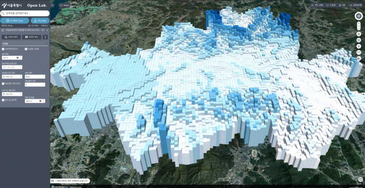
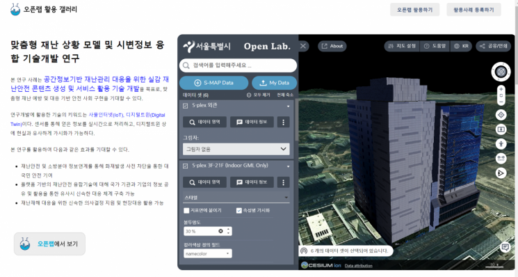
In this digital twin S-Map service, an open-source based open digital experimental space called ‘Open Lab’ will be introduced, where researchers and experts can experiment with and solve real urban problems. The Open Lab experimental space provides 3D spatial information and administrative data owned by the city, and researchers solving urban issues can visualize their research outcomes in 3D by integrating them with the city’s data using the provided spatial information.
By August, the Open Lab will be further enhanced to provide spatial information data and simulation development environments owned by the city for private industries, share user experiences, and implement various activation measures to support related future industries so that private companies and startups can create new technologies in the spatial information new industry.
Additionally, by utilizing the 3D digital twin information of S-Map and advanced technologies, the city will offer citizens enjoyable attractions, sightseeing spots, and useful information. In particular, diverse citizen experience pilot services will be introduced based on various devices, including metaverse XR, AR, VR, and MR.
The Seoul Metropolitan Government is increasing the utilization of S-Map in urban planning and urban regeneration fields. Notably, it has advanced the wind path simulation technology transferred through a memorandum of understanding (MOU) with the German Meteorological Office in 2020. Previously, wind path simulations were only possible with buildings in place, but now the wind path can assess the environmental impact depending on building arrangements.
In July this year, using S-Map data and extended reality (XR) technology, the city will launch the ‘S-Map XR Historical Experience Service with Haechi’ at Gyeongbokgung Palace, offering guidance, virtual space games, and restoration of lost old buildings in reality, allowing visitors to tour both the interior and exterior on-site.
Park Jong-su, Director of Smart City Policy at Seoul City, said, “With the rapid development of various devices and new technologies, we will not only create a citizen-centered digital twin S-Map service that satisfies citizens’ needs but also actively disclose the digital twin data owned by the city to the private sector to promote the development of new technologies and new industries.”
© The Asia Business Daily(www.asiae.co.kr). All rights reserved.


