After "No Risk of Damage" Announcement... Tsunami Hits, Special Warning Issued
Response System Enhanced Since Great East Japan Earthquake but 'Weaknesses' Revealed
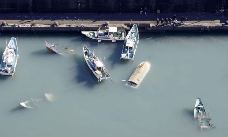 Due to the eruption of an underwater volcano near the South Pacific island nation of Tonga, a tsunami was observed in Japan. On the 16th, some small vessels were seen floating overturned on the water at the port of Muroto, Kochi Prefecture.
 [Image source=Yonhap News]
[Asia Economy Reporter Park Hyun-joo] It has been revealed belatedly that the Japan Meteorological Agency failed to accurately predict the damage caused to the Japanese archipelago by the tsunami generated from the underwater volcanic eruption in the South Pacific. Although Japan has been enhancing its response system since the Great East Japan Earthquake in March 2011, it was evaluated that this tsunami exposed vulnerabilities as they were.
According to local media such as NHK and Kyodo News, the Japan Meteorological Agency issued a tsunami warning and advisory at 0:15 on the 16th (Korean time) related to the large-scale eruption on the volcanic island of the Tonga archipelago. This warning came about 11 hours after the eruption occurred around 1 p.m. the previous day.
Japan has been upgrading its response system since suffering enormous damage from the tsunami during the Great East Japan Earthquake in March 2011. However, the Japan Meteorological Agency showed clear weaknesses regarding this tsunami that originated in Tonga, approximately 8,000 km away from the Japanese archipelago.
The Japan Meteorological Agency announced after 7 p.m. on the 15th that there might be slight changes in tide levels, but there was no concern about a tsunami hitting the Japanese archipelago.
However, this led to a situation where the tsunami struck without anticipation of its arrival in the Japanese archipelago.
The Japan Meteorological Agency issued tsunami warnings at 0:15 on the 16th for the Amami Islands in Kagoshima Prefecture and the Tokara Islands, and upgraded the advisory issued for Iwate Prefecture to a warning at 2:54 a.m., showing a delayed response.
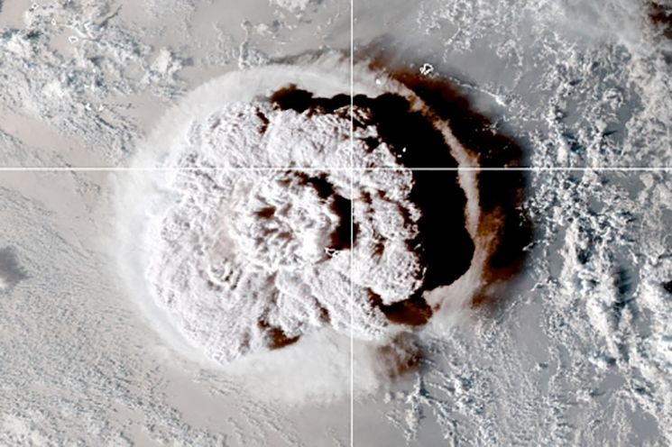 On the 15th, a submarine volcano erupted in the sea near the South Pacific island nation of Tonga, captured by a satellite from the U.S. National Oceanic and Atmospheric Administration (NOAA). As the submarine volcano erupted in the South Pacific on this day, tsunami warnings were issued across Tonga, the southwestern coast of Japan, and the western coast of the United States, with the eruption scene also observed from space. [Provided by a third party] [Image source=Yonhap News]
Furthermore, the Japan Meteorological Agency expected a tsunami up to 3 meters high, but the actual observed height was 1.2 meters at Kominato in the Amami Islands, resulting in a significant discrepancy between the late prediction and the actual observation.
The Japan Meteorological Agency explained that it failed to properly analyze the tsunami path, which is estimated to have traveled at about 800 km/h, by stating, "This tsunami was of a different nature than those generated by typical underwater earthquakes." Generally, tsunamis are caused by crustal movements due to earthquakes, but this tsunami is presumed to have been generated by an underwater volcanic eruption without an earthquake.
The agency stated, "The initial announcement of no tsunami concern was because no changes were observed at monitoring points between Tonga and Japan," and added, "We are currently analyzing the exact cause of the significant impact this eruption had on sea level changes in Japan."
Meanwhile, the tsunami caused physical damage such as fishing boats and small vessels capsizing while docked at Muroto Port in Kochi Prefecture. Evacuation orders were issued to approximately 230,000 residents across eight prefectures including Iwate.
© The Asia Business Daily(www.asiae.co.kr). All rights reserved.
![User Who Sold Erroneously Deposited Bitcoins to Repay Debt and Fund Entertainment... What Did the Supreme Court Decide in 2021? [Legal Issue Check]](https://cwcontent.asiae.co.kr/asiaresize/183/2026020910431234020_1770601391.png)


