Second National Road Network Comprehensive Plan
Reorganized into 10 North-South and 10 East-West Axes by 2030
Added Radial Axes Directly Connecting Surrounding Cities to the Five Major Cities' Circular Road Network
Supplemented Central Line and Central Inland Line Due to Excessive Distance Between Roads
[Asia Economy Reporter Kangwook Cho] The national arterial road network will be reorganized into 10 north-south axes and 10 east-west axes by 2030. This is the first change in over 30 years since 1992. Additionally, radial axes connecting surrounding cities and central areas will be added to the existing circular road networks of the five major metropolitan areas. The plan aims to create an environment where all citizens can access arterial roads within 30 minutes.
The Ministry of Land, Infrastructure and Transport announced on the 16th that it has finalized the "2nd National Road Network Comprehensive Plan" after review by the Road Policy Deliberation Committee. This plan, applied to the road network from this year until 2030 in 10-year increments, is the highest-level statutory plan in the road sector. The ministry explained, "It presents the tasks for the next decade centered on four values: economic re-acceleration, inclusion, safety, and innovative growth."
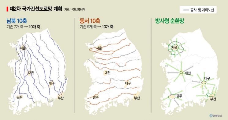
Through this plan, the national arterial road network, which forms the foundation of road construction, will change for the first time in over 30 years. Since 1992, the national arterial road network has operated as a grid of 7 north-south axes and 9 east-west axes, along with 6 circular networks in metropolitan areas, known as the ‘7×9 + 6R’ system. Going forward, this will be reorganized into a ‘10×10 + 6R²’ system, consisting of 10 north-south axes, 10 east-west axes, and 6 radial circular networks.
This reorganization introduces one new north-south axis and upgrades two north-south and one east-west branch lines (secondary routes) to arterial axes.
In particular, to supplement the distance between the Jungbu Line and Jungbu Inland Line and to disperse traffic volume on the north-south axes, a new sixth north-south axis will be introduced. Currently, the distance between the Jungbu Line and Jungbu Inland Line is about 73 km, more than twice the national arterial network average of 30 km. To disperse traffic volume on the north-south axes, a new section from Jincheon to Hapcheon will be introduced along the Yeoncheon?Seoul (Gangil IC)?Jincheon?Yeongdong?Hapcheon route. Additionally, long-distance routes currently functioning as arterial roads (Pyeongtaek?Buyeo?Iksan, Seoul?Sejong, Seoul?Chuncheon) will be upgraded from branch lines to arterial axes.
Alongside this, considering the transportation demand of metropolitan living areas, radial axes connecting surrounding cities and central areas will be introduced to the existing circular road networks of the five major metropolitan areas. The metropolitan areas with established circular networks are the Seoul Capital Area (2 networks), Daejeon?Chungju area, Gwangju?Honam area, Daegu?Gyeongbuk area, and Busan?Gyeongnam area. The plan envisions developing these into six radial circular networks (Radial Ring) by adding radial axes connecting the centers and outskirts of these circular networks. The Ministry of Land, Infrastructure and Transport explained that radial axes such as the Boryeong?Buyeo axis, Boeun axis, Taean axis in the Daejeon?Chungcheong area, the Hwasun axis in the Gwangju?Honam area, and the Seongju axis in the Daegu?Gyeongbuk area have been reflected, enabling future consideration of road network expansion according to changes in traffic conditions.
Furthermore, to build a people-centered road environment, the plan includes establishing a public transportation transfer system that closely connects various mobility options and expanding contactless services for rest area use and toll payments. It also defines the role of roads as platforms for future mobility and new transportation services such as autonomous vehicles and urban air mobility (UAM), and includes the full-scale introduction of various smart technologies in actual road construction sites.
The Ministry of Land, Infrastructure and Transport plans to announce the "2nd National Road Network Comprehensive Plan" within this month and will gradually release subordinate plans such as construction and management plans in line with the policy directions of the comprehensive plan. Lee Yunsang, Director of the Road Bureau at the Ministry, stated, "Based on the newly reorganized arterial road network, we will enable all citizens to access arterial roads within 30 minutes and use roads conveniently without congestion."
© The Asia Business Daily(www.asiae.co.kr). All rights reserved.
![Clutching a Stolen Dior Bag, Saying "I Hate Being Poor but Real"... The Grotesque Con of a "Human Knockoff" [Slate]](https://cwcontent.asiae.co.kr/asiaresize/183/2026021902243444107_1771435474.jpg)


